A glimpse into the future of downtown Da Nang
On the basis of the adjustments to the Da Nang Master Plan by 2030, with a vision towards 2045 approved by the Prime Minister in March 2021, the mapping of key zones with breakthrough thinking under a multidisciplinary perspective to create new impetus for the city’s development and improve its national and international-level competitiveness as well is the most important task set for today. The Da Nang Master Plan opens up many new development opportunities for the city’s growth in many potential areas, including the city’s central part.
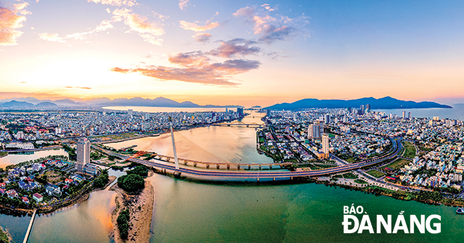 |
| Photo: HUY TUAN |
Development context of the planning of Da Nang’s central part
From 2010 to 2013, the Da Nang administration assigned a North American consulting team, including architect Kathrin Moore, and Dr. Ngo Viet Nam Son to act as the co-leaders of a research project on the adjustments to the Da Nang Master Plan by 2030, in collaboration with the Da Nang Institute of Urban Construction Planning.
The project was approved by the Prime Minister in 2013, on the legal basis of the Law on Planning 2009.
This project integrated the component plans into a unified whole, with the proposal of developing the central area on the eastern and western banks of the Han River in the direction of TOD (Transit Oriented Development), a type of urban development that maximizes the amount of residential, business and leisure space within walking distance of public transport.
This aimed to create busy multi-functional sea boulevards perpendicular to the coast, open public roads to the coast for privatized coastal areas, develop premise for the development of an aerotropolis, and an east-west tunnel running through the existing international airport to increase connectivity.
From 2018, in line with new requirements under the 2017 Planning Law, Singapore-based Surbana Jurong company, in collaboration with international consultants and the Da Nang Institute of Construction Planning, researched into the Da Nang Master Plan by 2030, with a vision towards 2045, including planning orientations for the city centre. This project was approved by the Prime Minister in March 2021.
Four strategic issues of planning and development
The upcoming planning and development of the central part of Da Nang should pay attention to the following four important strategic issues:
Define boundaries of the city centre with an open mind
The boundary of Da Nang’s central part can be determined according to the following limits: the eastern coastal boundary - Nguyen Van Thoai - Tran Thi Ly Bridge - Duy Tan Street - the boundary adjacent to Da Nang international airport - the south adjacent to Cam Le River - Tien Son Bridge - Ho Xuan Huong Street.
In addition, it is necessary to carry out urban planning in parallel with the airport planning. Da Nang has the potential to develop the aerotropolis model, which is a very new trend in the world.
Organize 5 planning components of the central area with specific identities
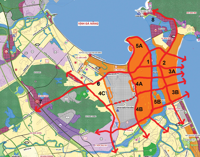 |
| Long-term vision for Da Nang center: (1) Administrative center (Civic Center); (2) Central Business District ; (3A-B ) Central coastal area; (4A) Da Nang Airport aerotropolis; (5A) Central area of Da Nang Bay; (5B) the central zone to the South of the Han River (Source: Ngo Viet Nam Son) |
The Da Nang Centre can be organised with 5 central components with diverse identities as follows:
Firstly, the Civic Centre on the western bank of the Han River, can be embellished and developed from the existing center area, with highlights being the municipal Administrative Centre, the Dien Hai Citadel, museums, cultural and historical works, markets, hotels, office buildings and commercial service areas surrounding the City Square, connecting with the chain of service - commerce - tourism projects along the edge of the city. The two banks of the Han River run in the north-south direction.
Secondly, the Central Business District (CBD), an international financial and commercial service zone on the eastern bank of the Han River, is home to the city's main economic and financial buildings, high-rise office buildings, commercial service areas and hotels surrounding the international square.
The CDB’s highlight is the new high-rise centre which can be renovated from the Son Tra District-based old An Don Industrial Park, which is now known as the Da Nang Industrial Park. This will be a 24/7 urban area where Da Nang's international trade and integration activities will be concentrated.
Thirdly, the marine tourism centre comprising the East Sea Park square and public parks along the coast. This is the place to organize tourist festival activities, connecting the central avenues in the east-west direction.
Fourthly, the centre of the future Da Nang aerotropolis includes the functions of aviation logistics, commercial services, hotels, the Da Nang international airport’s terminal areas and a group of central commercial services in and outside the airport, boasting convenient connection with a high-speed railway station, a bus station and car parking garages.
Fifthly, the urban area along the Han River with2 central zones at both ends: The central zone of Da Nang Bay whilst the central zone to the south of the Han River with the highlights being the amusement park and fitness - sports facilities.
The multi-pole centre areas with convenient trafffic connections
The five components of the above-mentioned central area need to be connected with one another through convenient traffic systems. In particular, the urban area of the high-speed railway station to the west is the railway and road gateway of the central area, with logistics functions for passenger transport and commercial services and hotels. Meanwhile, the Tien Sa port urban area is the waterway gateway of the central area offering waterway passenger transport logistics, commercial services, hotels, international cruise ship terminals, tourist marinas and water taxis.
Organise the public transport network in the east-west and north-south direction
The central area of Da Nang needs to open up diverse and open traffic types with intelligent management to avoid congestion.
The north-south and east-west routes can help form a bus network that covers the entire central area of Da Nang, thus reducing the risk of traffic congestion and allowing all residents to choose public transport means in lieu of private ones.
In particular, special attention should be paid to two important arterial avenues:
Firstly, the axis of Dien Bien Phu - Le Duan - Song Han Bridge - Pham Van Dong is the most important central axis in the east-west direction, not only connecting the chain of the 5 central urban areas mentioned above, but also directly connecting to the infrastructure hubs of the railway, metro and bus stations.
Secondly, the national highway 14B - road AH17 in the north-south direction, connecting the central area with the Tien Sa Port urban area to the north, and with the coastal tourist area to the south and with Hoi An City of neighbouring Quang Nam Province.
The central area of Da Nang needs to be planned and developed methodically, with a modern civilized face, commensurate with the city’s stature as a central urban hub of the central key economic region in the 21st century, towards the already-outlined strategic development objectives of building Da Nang into one of the major socio-economic centres of the country and Southeast Asia at large, cum a hub for innovative startups, tourism, commerce, finance, logistics, high-tech industries, information technology and supporting industries.
Reporting by Dr. NGO VIET NAM SON – Translating by A.THU