Logistics considered as a development lever in airport subdivision
The Da Nang Management Board of Traffic Work Construction and Investment Projects is coordinating with the Quang Nam Institute of Urban and Rural Planning JSC to make a planning project at a scale of 1:2000 for an airport subdivision. The project developers are collecting comments and opinions from the community to carry out next steps.
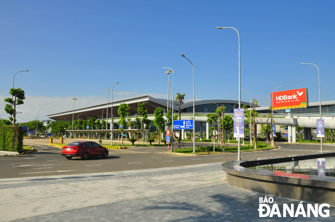 |
| Da Nang International Airport is the core point of the airport subdivision. Photo: THANH LAN |
New urban area in the heart of the city
Under Da Nang's adjusted master plan towards 2030 with a vision to 2050 approved by Prime Minister, the airport subdivision belongs to the Green Core Zone. The Zone is bounded by Cach Mang Thang Tam Street to the south, Truong Chinh Street to the west, Dien Bien Phu Street to the north, and Nguyen Tri Phuong and Nguyen Huu Tho streets to the east.
Accordingly, the subdivision includes administrative boundaries in the wards of Hoa Cuong Bac and Hoa Thuan Tay in Hai Chau District; Thac Gian, Chinh Gian, Hoa Khe and An Khe wards in Thanh Khe District; and Khue Trung, Hoa Tho Dong and Hoa Phat wards in Cam Le District.
The subdivision will consist of Da Nang International Airport and a logistics cluster. The goal is to maximise the airport's potential as a logistics hub, in tandem with developing the airport’s central location into a major public hub in Da Nang.
Currently, the area is now home to many projects being and about to be implemented, as well as many projects that need to be zoning planning to define specific functions for each land area.
Therefore, it is necessary to make a plan to adjust the airport subdivision planning at the scale of 1:2000, which is considered as a basis for making adjustments to the detailed planning and determine construction investment projects in order to serve the urban management and construction, and to meet the needs of socio-economic development in planned areas in particular and the city in general.
Under the planning project, the airport subdivision is oriented to develop as a ‘airport urban’ development model. Specifically, the airport subdivision has Da Nang International Airport as the centre, whilst residential areas, commercial and service facilities, and other urban functional areas are arranged around. Located on the east-west axis, the subdivision connects with the ‘Subdivision along the Han River and its eastern bank’ and the green core subdivision.
The airport subdivision will feature 4 main development areas. In the first area, Da Nang International Airport is the international gateway to Central Viet Nam, whilst the second area is the gateway to the east of the airport with the orientation of developing public areas, commercial centres and tax-free areas to gradually form an ‘airport urban’ model.
The third area is the southern urban area focusing on urban reconstruction, the upgrading urban technical infrastructure system, and adding urban utilities. The remainder is the northwest urban area which will be embellished and rebuilt, and have technical infrastructure systems to be upgraded.
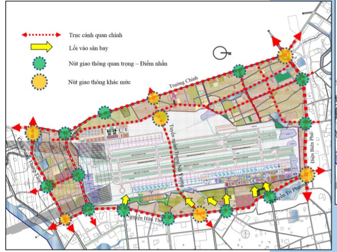 |
| A detailed planning map of the airport subdivision |
Priority given to exploiting underground space
The airport subdivision prioritises the exploitation of underground space because more than 50% of the division’s area is located in the airport area.
Accordingly, underground space will be developed at commercial, service, public and hospital land lots. Parking lots also use underground space to optimize space usage.
In terms of depth, the plan is divided into 3 levels with separate functions. In particular, shallow level with the depth of 0-5m serves the construction of underground technical infrastructure such as basement entrance and pedestrian tunnels. Medium depth level of 5-15m will be used to build public works and underground parking, whilst technical infrastructure works will be constructed at the deep level of over 15m.
Additionally, there will be an underground road tunnel along Trung Nu Vuong Street passing through the airport, combined with the MRT subway line.
Regarding urban design, on the basis of determining land use functions, planning criteria - architecture and technical infrastructure will be developed.
Notably, the regulation on the height limit for construction in the airport subdivision depends on the regulations on the airport static, the flight funnel.
Specifically, individual housing projects will have a maximum height of 5 floors, and public works with a maximum height of 3 floors. Meanwhile, the maximum height of public works, commercial centres and apartments is allowed according to the height limit diagram of the airport, but it must not exceed 45m.
Airport terminals, and logistics and technical infrastructure works will be built according to the height limit diagram of the airport.
In the airport subdivision, Da Nang International Airport and a new modern logistics cluster will be the centre. The subdivision will showcase the harmonious combination of existing features such as the water surface - green tree system, public works, trade and service, and stable residential areas through public spaces, traffic and the transition spaces that are organized and continuously connected to create the airport urban model.
Reporting by TRIEU TUNG - Translating by M.DUNG