GeoData application in survey, design, construction investment management
The Da Nang Department of Transport has just coordinated with GeoData Joint Stock Company to organize a workshop on the application of GeoData in surveying, design, and construction investment management with the participation of experts and engineers from survey, design, supervision, and project management units in Da Nang.
 |
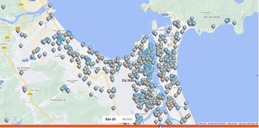
| Here is the image of the current status of geological information through the GeoData application in Da Nang. Photo: The Da Nang Department of Transport |
The workshop hopes to soon approach and form a digital management and application system for engineering geological information, creating connection among survey and design management agencies, training facilities at universities nationwide. At the same time, the event aims to help the city optimize the process of surveying, designing, approving documents as well as managing data, teaching and research.
Inevitable transformation trend
According to Deputy Director of the Da Nang Department of Transport Luong Thach Vy, digital technology and new technology applications in the ongoing Industry 4.0 are inevitable and mandatory trends for businesses and State management agencies if we do not want to fall behind and right behind other industries that have digitally transformed and applied the above new technologies in Viet Nam. Today, digitalization goes one step further than digital transformation.
Digitalisation collects data from digital transformation and uses it in virtual environments to create innovative solutions. An example of the current digital application is the requirement to use Building Information Modeling (BIM) according to Decision No. 258/QD-TTg dated March 17, 2023 by the Prime Minister.
Accordingly, the roadmap for applying BIM in construction activities into the implementation of projects using public investment capital and investment partnership modes. Specifically, with a regard to the purpose, the BIM application aims to improve the quality of design products, strengthen the information exchange process between State management agencies in charge of construction, investors, consulting organisations, and construction contractors.
During the construction process, it supports the development of construction organization plans, manage resources during the construction process and control construction quality. During the acceptance process, there is the handover and putting the project into use, supporting the acceptance process, serving the management and operation phase of the construction project.
For State management agencies, the use of the BIM model as a tool to support the process of performing State management tasks (appraisal of feasibility study reports, construction design and implementation) after basic design; construction licensing; construction management; the inspection of acceptance work...).
At the same time, depending on the requirements of the basic design, construction design implemented after the basic design and construction completion documents, when applying the BIM model, the BIM file needs to meet a number of requirements such as showing the building's architecture and main dimensions; three-dimensional shape of the main structures of the building; air conditioning, ventilation, water supply and drainage piping systems.
Some drawings of detailed parts are in two-dimensional space to supplement information that must be in digital format when submitted with the BIM file. Drawings and main volumes of construction parts must be extracted from the BIM file.
Required solution
With raged to the roadmap for applying BIM, during Phase 1, starting from 2023, the application of BIM is mandatory for level I and special level works of newly used construction investment project using public investment capital, State capital other than public investment and investment in the form of public-private partnership.
Phase 2 will run from 2025, with the mandatory application of BIM to level II works or higher of new construction investment projects using public investment capital, State capital other than public investment and public-private partnership. It is known that the mission of developing and perfecting infrastructure, and the transportation industry in particular, in the current period will be extremely "busy", associated with many challenges and responsibilities.
Therefore, actual requirements do not allow project design, survey and management units to operate and manage in old ways based on discrete data and the shortage of synchronization and connection during management process. Reality requires improvement and new management methods, new technologies with centralised, synchronised data sources and open, shared data sources, so digital is the mandatory solution of all times.
One of the practical applications and effects of managing and having data on engineering geology from digitalisation is to have a basis for calculating construction plans to avoid weak and unstable ground locations so as to reduce project implementation costs.
Based on information about stratigraphy and project geology, investment preparation and design units have the basis to determine relatively accurate investment costs right from the step of preparing a pre-feasibility report or investment policies of projects/works and limit the occurrence and major deviations in project implementation costs during the implementation process.
GeoData data source is the basis for appraisal agencies to verify survey data and is the data source basis for determining data development direction of the city's underground space.
Reporting by GIA MINH - Translating by A.THU