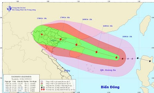
Storm Kalmaegi heading for northern coastal provinces
According to the Central Centre for Hydro-Meteorological Forecasting, Tropical Storm Kalmaegi, which crossed the northern Philippines yesterday, has entered the East Sea early this morning.
At 7pm today, the storm should be positioned at latitude 19°4’N and longitude 115°4’E, about 450km northeast of the Hoang Sa archipelago. It is predicted to carry wind speeds of 134 - 149kph (level 11/12) near its centre.
During tomorrow, the storm is expected to continue moving in a westerly or north-westerly direction at a speed of between 25kph and 30kph.
 |
| The predicted track of Storm Kalmaegi |
By 7pm tomorrow, 16 September, the storm’s position is predicted to be at latitude 21°N and longitude 109°E, about 170km east of the coastal areas from Quang Ninh to Hai Phong provinces.
Due to the effects of this storm, the eastern part of the East Sea is experiencing thundery showers and strong winds at level 8/9. The Da Nang area and other parts of the coastal area from Quang Nam to Binh Thuan provinces are expected to experience moderate rain and thunderstorms accompanied with very strong winds, and even whirlwinds, from the southwest at level 2/3.
To prepare for the arrival of the storm with its complicated development, the city’s Steering Committee for Flood and Storm Control and Mitigation, Search and Rescue has asked local relevant agencies to keep local fishermen fully informed about the evolution of the storm so that they can avoid the affected areas.
According to the Da Nang Border Guard Command, there were 2,115 fishermen on 242 fishing vessels operating at sea as at 5.30pm yesterday. Of these, the 20 boats operating in the directly affected areas are moving out of the storm’s danger area.