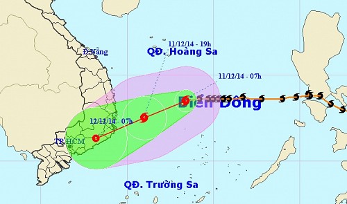
Storm Hagupit likely to hit Ninh Thuan-Binh Thuan area tonight
Tropical storm Hagupit has regained strength in the East Sea after being downgraded and will likely make landfall in Viet Nam’s south-central coast tonight, the Viet Nam National Center for Hydro-Meteorological Forecasting warned on Thursday morning.
At 8 pm Wednesday, when located 250 km north-northeast of Song Tu Tay Island, part of Viet Nam’s Truong Sa (Spratly) archipelago, the storm was packing winds of up to 102 km, much stronger than its maximum winds of 74 kph a day before, said Hoang Duc Cuong, director of the center.
At 4 am Thursday, the storm was centered 240 km north of Song Tu Tay Island, packing winds of up to 88 kph and squalls of 103-133 kph, the center reported.
 |
| The expected path of storm Hagupit in the East Sea |
The storm is moving west at a speed of 20 km but may change direction to west-southwest, heading for Viet Nam’s south-central coast.
In the most likely scenario, the storm will weaken into a tropical depression with winds of 39-61 kph when it is 100-150 km off the coast between the south-central provinces of Khanh Hoa and Binh Thuan, Cuong said.
Hagupit will then reach land in the Ninh Thuan-Binh Thuan area on Thursday evening, he said.
In another possibility, the storm will weaken as it nears the south-central coast and will then drift southward along the coast between Ba Ria-Vung Tau and Ben Tre provinces, bringing rain and thunderstorms to the southern region, he added.
Due to the storm, the waters off the coast from Binh Dinh to Binh Thuan provinces will face rough seas and winds of up to 74 kph and gusts of 75-102 kph from Thursday afternoon.
At the same time, the coastal localities between Phu Yen and Binh Thuan provinces will experience winds of 39-61 kph and gusts of 62-88 kph.
Meanwhile, powerful sea waves, with a height of 2-4 meters or higher, will be seen in waters from Da Nang to Vung Tau.