Storm heading to central region
According to the National Centre for Hydro-Meteorological Forecasting, a tropical depression has strengthened into a storm which is now heading towards the central region.
At 4am today, 14 September, the storm’s centre was positioned at latitude 15°7’N and longitude 110°6’E, about 220km off the east coast from Da Nang to Quang Ngai Province. The strongest wind speeds near its centre were between 60 and 75kph (level 8).
At 4pm today, the storm’s position is expected to be at latitude 15°8’N and longitude 108°9’E on the coastal areas from Da Nang to Quang Ngai Province. It is predicted to carry wind speeds of 60 - 75kph near its centre.
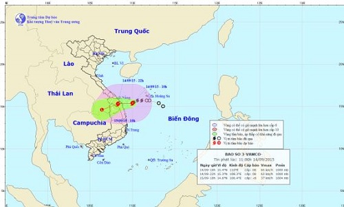 |
| The predicted movement of the storm |
For the next 24 hours, the storm should continue moving in a westerly direction at a speed of between 10 and 15kph. It is predicted to hit mainland areas from Da Nang to Quang Ngai Province and produce heavy rainfall before weakening into a depression and then into a low pressure system.
Due to the effects of the storm, the Hoang Sa archipelago and the waters off the central region are experiencing strong winds at level 9/10 and rough seas. From this afternoon, the Da Nang area and other parts of the coastal area from Quang Binh to Quang Ngai provinces should encounter strong winds at level 8/9.
To prepare for the arrival of the storm, the city’s Steering Committees for Natural Disaster Mitigation and Control, and Search and Rescue, has asked the local Border Guard High Command and the Coastal Information Station to keep all fishing boats operating at sea well informed of its position, direction and movement. This will allow them to take the initiative to avoid dangerous areas or seek safe shelter from the storm. Local offshore fishing boats are not being allowed to head out to sea, and relevant agencies are being asked to keep in close contact with boats at sea in order to handle any unexpected incidents.