Rough seas, lashing winds imminent in Viet Nam's waters as tropical storm Aere brews
The storm Aere is forecast to approach the East Viet Nam Sea later this week, bringing rough seas and strong squalls to Viet Nam’s waters.
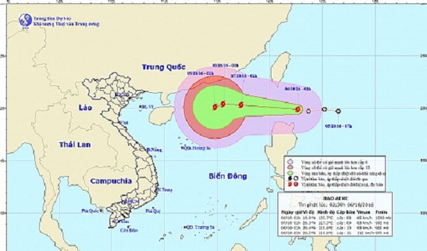 |
| Tropical storm Aere’s expected path Nat’l Center for Hydro-Meteorological Forecasting |
With current winds between 60 and 75 kph, tropical storm Aere began forming on Thursday from a depression at 19.9 degrees latitude north and 122.7 degrees longitude, according to the National Center for Hydro-Meteorological Forecasting.
Over the next 24 hours, the storm is predicted to close in on the northeastern area of the East Viet Nam Sea at speeds between 20 and 25 kph, packing on more strength as it moves west-northwestward.
By 1:00 am on Friday, Aere is expected to move about 680 km to the northeast of the Hoang Sa (Paracel) archipelago, with winds reaching 10-11 on the Beaufort scale.
Turning westward, the tempest is likely to carry winds of 75-100 kph as it travels to an area just 550 km northeast of the Paracels by 1:00 am on Saturday.
The weather center predicts that Aere will slow to 5 kph but carry more power as it makes its way west-southwestward on Sunday.
Severe rough seas and strong squalls at 11-12 on the Beaufort scale are imminent in the northern area of the East Viet Nam Sea, while downpours, gales, and waves reaching 2.5 meters should be expected in the southern waters from Binh Thuan to Ca Mau provinces.
(Source: Tuoitrenews)