Storm Tokage dissipates; cold spell closes in on northern Viet Nam
Storm Tokage has weakened to form a low-pressure system but is anticipated to bring rain to the central region while a cold front will cause brisk conditions in the north.
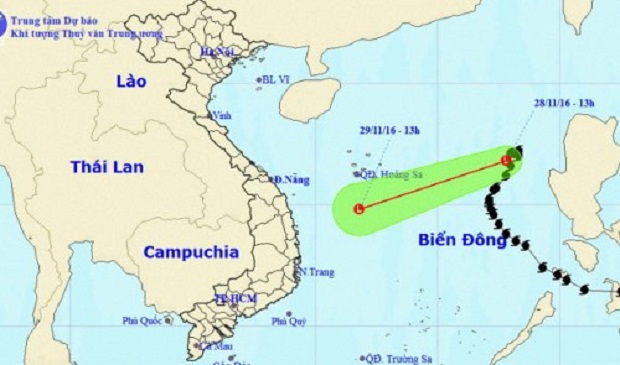 |
| This map shows the centre of the low-pressure area. |
Central weather forecasters have said that the tropical depression, which storm Tokage had been downgraded to, became an even weaker low-pressure area on Monday afternoon.
At 1:00 pm that day, the center of the system was 550km east of Viet Nam’s Hoang Sa (Paracel) archipelago, packing winds just below 40km per hour.
The low-pressure area will move quickly west to southwest before weakening again and dissipating.
In the wake of the storm and low-pressure system, the northern part of the East Sea, including Hoang Sa, and the waters off the central coast are expected to be hit by strong winds and rough seas for the rest of Tuesday.
From Tuesday night to Friday, rainfall can be anticipated in the region from Da Nang to Khanh Hoa Province while the area from Quang Nam to Phu Yen provinces will be stricken by heavy downpours.
Forecasters have said that flash floods and landslides should be expected in small and medium rivers, as well as in the mountains.
At the same time a cold spell is moving toward the northern region, bringing with it bleak climate conditions.
It is forecast to be cold in the northern cities and provinces, as well as in the region stretching to Hue City, over the next 3 days.
(Source: Tuoitrenews)