Haikui weakens into a depression, showers possible in the city next few days
The National Centre for Hydro-Meteorological Forecasting (NCHMF) says Typhoon Haikui, this year’s 13th storm, weakened into a tropical depression on Sunday after having entered the East Sea.
 |
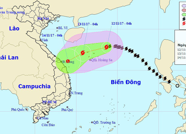
| The expected path of the low pressure system (Photo: NCHMF) |
At 7.00pm on Sunday, the depression’s centre was positioned at latitude 17°2’N and longitude 111°3’E, northwest of the Hoang Sa Archipelago, packing wind speeds of 40 - 50 kph (level 6) near its centre, and gusts of level 8.
Afterwards, the depression moved southwestwards at a velocity of about 10 - 15km an hour, and continued downgrading to a low pressure system.
At 7.00pm today, Monday (13 November), the low pressure system is expected to be located at 15°7’N and longitude 109°5’E, off the coastline from Quang Tri to Quang Ngai provinces. The strongest wind speed is predicted to reach only 40 kph (under level 6).
According to the National Steering Committee for Natural Disaster Mitigation and Control, some central regional localities, especially from Quang Tri to Quang Ngai provinces, are expected to experience the rainfall of between 150mm and 200mm over the next few days, even between 300mm and 400mm in some of their parts.
According to the NCHMF, no rain is likely in Da Nang tonight, and scattered showers are possible in some of the city’s parts in the next few days.