Heavy rain threat for the city
According to the National Centre for Hydro-Meteorological Forecasting (NCHMF), the 12th storm of this year, internationally named Damrey, is predicted to continue to grow in strength as it moves closer to south-central Viet Nam this weekend.
 |
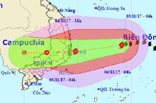
| The expected path of storm Damrey |
At 1.00 pm today, 3 November, the typoon’s centre was positioned at latitude 12°8’N and longitude 120°0’E, about 300km east off the coastline from the Khanh Hoa to Ninh Thuan provinces, packing strong winds of 90 and 115 kph near its centre (level 10-11) and gusts of level 14.
At 4.00am tomorrow, 4 November, the storm is expected to make a direct landfall over the coastline from the Khanh Hoa to Ninh Thuan provinces, packing strong winds of 110 and 135 kph near its centre (level 11-12) and gusts of level 15.
Afterwards, the storm is expected to move westwards at a velocity of 20km per hour, and it is likely to strike the mainland of the south-central regional localities, and then weaken into a tropical depression.
Tomorrow afternoon, the depression’s centre is located at the Viet Nam- Cambodia border with strong winds of 40 and 60 kph (level 6-7), and then, it will be likely to weaken and dissipate there.
Due to the effects of storm Damrey and a cold spell advancing southward, central localities from Quang Tri to Binh Thuan, including Da Nang, are forecast to see very heavy rain from this afternoon.
From early morning of 4 November onwards, the coasts of the localities of Da Nang, Quang Nam, Quang Ngai and Binh Thuan are expected to experience winds at level 6-7, with gusts of level 9.
Meanwhile, strong winds at level 9-1, with gusts of level 14, are likely to batter the south central localities of Binh Dinh, Phu Yen, Khanh Hoa and Ninh Thuan.
Between 4 and 8 November, big flooding is expected to lash the localities from Thua Thien Hue to Khanh Hoa and northern central highlands.