Heavy rain warning for the city as storm Damrey heading towards south central region
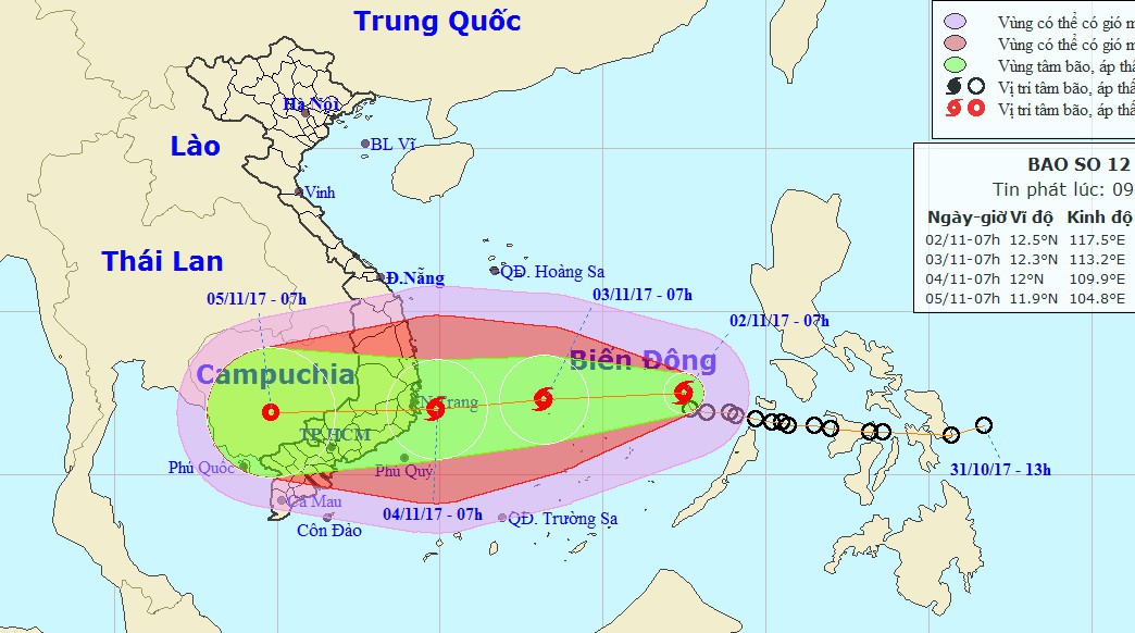
According to the National Centre for Hydro-Meteorological Forecasting (NCHMF), a tropical depression has strengthened into the 12th storm of this year, internationally named Damrey, which is heading towards the south central region.
 |
| The predicted path of the storm |
At 7.00 am on 2 November, the storm was positioned at latitude 12°5’N and longitude 117°5’E, about 380km east-northeast of Song Tu Tay Island, packing strong winds of 60 and 75 kph near its centre (level 8) and gusts of level 10.
Over the next 24 hours, the storm is expected to move westwards at a velocity of 20km per hour, and it will be likely to grow stronger.
At 7.00am on 3 November, the storm’s centre is predicted to be at 12°3’N and longitude 113°2’E, about 420km off the coast of the Binh Dinh to Ninh Thuan provinces, with strong wind speeds of between 75 and 100kph (level 9/ 10) near its centre, and squalls of level 14.
Due to the effects of this tropical storm, the central area of the East Sea, including sea waters north of the Truong Sa Archipelago will see rough seas, thunderstorms and strong winds at level 6/7, and level 9/10 near the storm’s centre.
At 7.00am on 4 November, the storm’s centre is forecast to be at 12°0’N and longitude 109°9’E, battering the coastline along the Binh Dinh to Ninh Thuan provinces. The strongest wind speeds near the storm’s centre will be between 90 and 115kph (level 10/11) near its centre, and squalls of level 14. A cold spell will advance southward at the same time.
According to NCHMF, from tonight, 2 November, sea waters off the coast of the mid-central and south central regions are expected to experience strong winds at level 6/7, and squalls of level 6.
According to the Mid-Central Region Centre for Hydro-meteorological Forecasting, over the next hours, Da Nang is predicted to see scattered showers at night in some local parts. In addition, there will be north-easterly winds at level 2/3, sea waves from 0.75 to 1.75m high, and slightly rough seas.
However, according to NCHMF, very heavy rains will lash Da Nang starting from Friday.
Also, under the combined influences of the stormy and rainy weather patterns, rain will batter other localities, namely Thua Thien-Hue, Quang Nam, Quang Ngai, Binh Dinh, Phu Yen and Khanh Hoa Provinces, in some days.
In related news, NCHMF has recently urged the National Secretariat of APEC 2017 to join efforts with other relevant agencies to cope with stormy and rainy weather patterns exacerbated by floods which might happen next week during the APEC Economic Leaders’ Week in Da Nang.