Newest storm could be formed, another depression could bring rain to the city
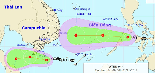
According to the National Centre for Hydro-Meteorological Forecasting (NCHMF), a new tropical depression recently formed in the sea area just east of the Philippines is forecast to enter the East Sea. The depression is likely to strengthen into the 12th storm of this year, and it might bring heavy rainfall and rough seas.
 |
| The predicted paths of the 2 tropical depressions (Photo: NCHMF) |
At 10.00 pm on 31 October, the depression was located at latitude 11°3’N and longitude 123°2’E, about 420km east of the Palawan Island, packing strong winds of 50 and 60 kph near its centre (level 7) and gusts of level 9.
Over the next 24 hours, the depression is expected to move in a west-northwest direction at a velocity of between 20 and 25km per hour, and it might strengthen into a storm which is predicted to head towards the East Sea this afternoon (1 November).
At 10.00pm today, the storm’s position is predicted to be at latitude about 12°1’N and longitude 118°5’E in the sea area east of the East Sea, about 460km east-northeast of Song Tu Tay Island, with maximum winds of between 60 and 75 kph (level 7) and squalls of level 10.
Over the next 48 hours, the storm is forecast to move westwards at a speed of between 15 and 20km per hour, and will likely to be stronger.
In related news, another depression is heading west-northwest at 15-20 kilometers per hour, and is expected to pass by Viet Nam's southernmost point on Wednesday afternoon. Under the influence of the depression, heavy rain, tornadoes and strong winds are forecast to batter Viet Nam's southern coast areas from Binh Thuan to Ca Mau provinces, plus Phu Quy and Con Dao islands.
Southern and south central provinces could also experience rains of up to 200 millimeters from Tuesday night until the end of Thursday.
In particular, some parts of Da Nang will see scattered light showers over the next few days.