Showers possible in the city tonight, Depression upgraded to Typhoon Haikui
According to the National Centre for Hydro-Meteorological Forecasting (NCHMF), on Thursday evening, a newly-formed tropical depression near the Philippines was upgraded to a typhoon, internationally named Haikui. On Friday morning, Haikui entered the East Sea after it had passed over the Luzon Island of the Philippines, becoming Viet Nam’s 13th typhoon of this year.
 |
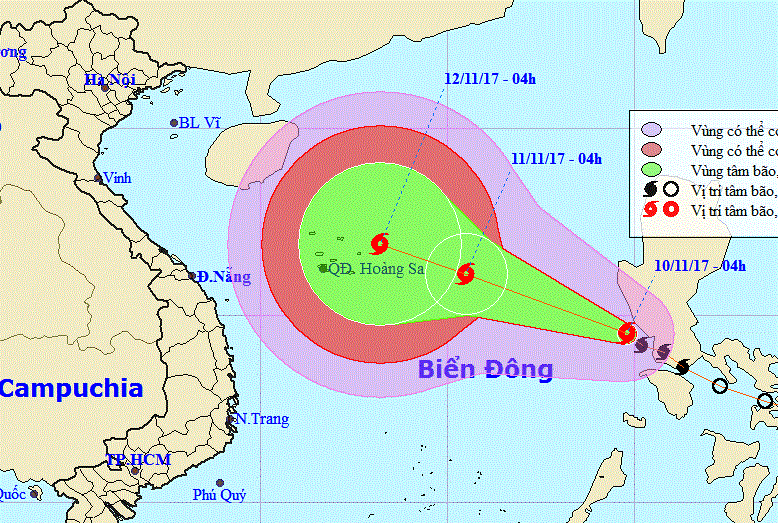
| The expected path of the typhoon (Photo: NCHMF) |
At 4.00am on Friday, the storm was positioned at latitude 14°5’N and longitude 119°8’E, about 930 km southeast of the Hoang Sa Archipelago, packing wind speeds of 60 - 75 kph (level 8) near its centre, and gusts of level 10.
Over the next 24 hours, the storm is forecast to continue moving in a west-north-west direction at a velocity of about 20km an hour, and it is likely to grow stronger.
At 4.00am tomorrow, Saturday (11 November), the storm’s centre is expected to be located at latitude 16°1’N and longitude 115°5’E, about 430 km southeast of the archipelago. The strongest wind speed will reach between 75 - 90 kph (level 9) near the storm's centre, and gusts of level 12.
At 4.00am on Sunday (12 November), the typhoon’s centre is predicted to be on the sea water east-northeast of the archipelago. The strongest wind speed will be between 75 - 100 kph (level 9-10) near the storm's centre, and squalls of level 13.
Due to the effects of this newly-formed storm, the eastern area of the East Sea is forecast to experience very rough seas, heavy thunderstorms, showers and strong winds at level 8-9 near the storm’s centre, and gusts of level 11-12.
In Da Nang, scatter showers are possible tonight.