Depression likely strengthening into storm, rain expected to continue into Friday
A low-pressure system near the Hoang Sa (Paracel) Archipelago is likely to strengthen into a storm in the East Sea tomorrow morning (5 June), the National Centre for Hydro-meteorological Forecasting (NCHMF) has warned.
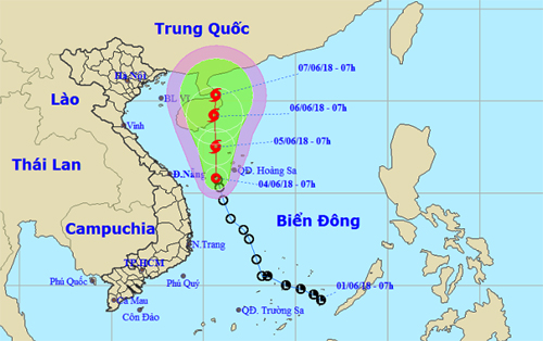 |
| A map detailing the expected journey of the tropical depression from 4 to 7 June |
At 1.00 pm on Monday, 4 June, the depression’s position was positioned at latitude 15°8’N and longitude 110°6’E, to the southwest of the Hoang Sa Archipelago, packing wind speeds of 50 - 60 kph (level 6) near its centre, and gusts of level 9.
Over the next 24 hours, the tropical depression is forecasted to move northwards at a velocity of between 5 and 10 km an hour, and it is likely to upgrade into a storm.
At 1.00pm tomorrow, the storm’s centre is predicted to be located at latitude 17°8’N and longitude 110°7’E, right on the southeastern coast of Hainan Island in China.
According to the national forecasters, under the influence of the ongoing depression, Da Nang is expected to continue experiencing moderate to heavy rain, along with thunderstorms, until Friday, 8 June.
The average temperatures are predicted to hover at between 25 and 34 degrees Celsius.
The northern part of the East Sea, including the Hoang Sa Archipelago, is also bracing for strong winds of level 6 - 7, with gusts of level 10, and heavy rough seas over the next few days.
The depression has already caused downpours in Quang Ngai and Binh Dinh provinces, whose low areas are at high risk of landslides and flash floods.