Tracking tropical depression expected to strengthen, head towards south-central Viet Nam
A tropical depression has entered the East Sea and could strengthen into a typhoon this evening, according to the National Hydro Meteorological Forecasting Centre (NCHMF). This system could threat south-central Viet Nam in the next 2 days, becoming the 9th storm to hit the country this year.
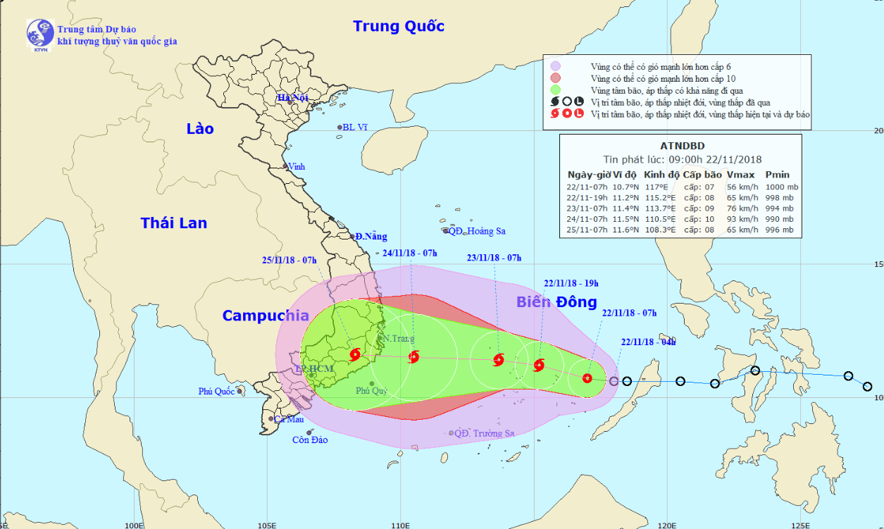 |
| A map detailing the track of the 9th typhoon (Photo: NCHMF) |
Currently, tropical storm warnings have been issued for localities from Quang Ngai to Ba Ria- Vung Tau provinces.
NCHMF says the low-pressure system first formed in a maritime area east of the Philippines around Monday and has since been travelling westward. It hit the East Sea early Thursday morning.
As of 7.00 am on the same day, the tropical depression was located about 300 kilometers southeast of Song Tu Tay Island in Viet Nam's Truong Sa (Spratly) Archipelago.
Average wind speeds were recorded at 50 to 60 kph with gusts at up to 88 kph.
It is likely to gather enough strength to become a tropical storm within the next 12 hours.
In the next 12 to 24 hours, the storm is forecast to travel northwest as it continues to amass strength.
According to NCHMF, the typhoon’s direction and power is hard to predict as it might interact with a cold spell advancing southward.
The combination of the typhoon and cold spell could allow the wind speeds to reach 75-120km per hour when it enters the Truong Sa (Spratly) Archipelago, the centre said.
At 7.00am on Friday, the typhoon is predicted to be located at latitude 11°7’N and longitude 111°5’E, about 250km east off the coast of southern central localities, with maximum wind speeds near its center reaching 75- 100 kph (level 9-10), gusting at level 12.
The storm will head toward the mainland and reach within 160 kilometers of the south-central Viet Nam coast on Saturday morning, with wind speeds increasing to between 75 and 100km per hour.
At 4:00 am on Sunday, the storm is predicted to move westward at a velocity of about 10km per hour. Its centre is expected to be positioned at latitude 11°6’N and longitude 108°7’E, right on the mainland of the southern central localities with the disaster risk level 3.
Downpours are expected to batter coastal provinces from Quang Tri to Binh Thuan with total amount of up to 300-500mm.
The highest volume of rain is predicted to fall between Friday and next Wednesday.
In the next 3 days, Da Nang is likely to see wet weather with the temperatures hovering at between 21 to 29 degrees Celsius, whilst the lowest humidity is reported as around 73%.