Storm to hit northern Viet Nam Thursday; city sees scattered showers
A tropical depression strengthened into a typhoon, internationally known as Mun, this morning, becoming the second formed in the East Sea so far this year, and it is forecast to make landfall in the north on Thursday morning, the National Hydro Meteorological Forecasting Centre (NCHMF) has warned.
 |
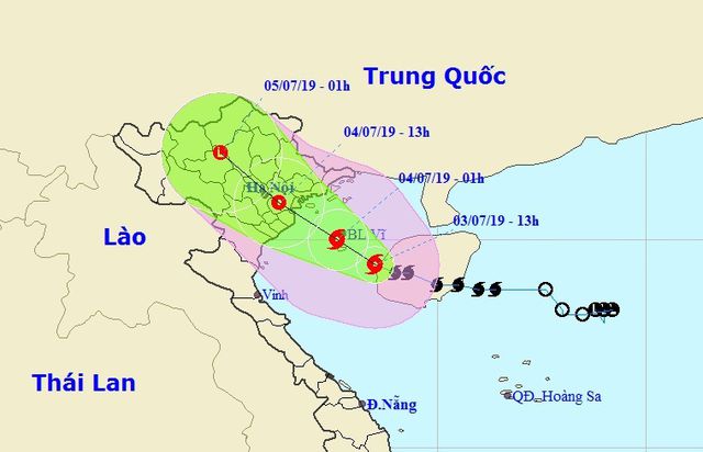
| A map detailing the track of the storm |
At around 7.00 am on Wednesday, the storm was located 220km from the Bach Long Vi Island in the Tonkin Gulf and around 340km south-southeast of Quang Ninh where is home to the world-famous Ha Long Bay, with winds of 75 kph.
The storm is predicted to move west-northwest at a velocity of about 15km per hour for the next 24 hours. Its centre would be on the coast between Quang Ninh and Ninh Binh Provinces by 7.00 am on Thursday, with wind speeds remaining unchanged, before weakening to a tropical depression covering the northern mountainous and midland areas.
Due to the effects of the tropical storm, rough waters and strong winds are expected to occur in the Tonkin Gulf, especially coastal areas in the northern localities from Quang Ninh to Nam Dinh provinces.
Torrential rain, flash floods, and landslides will probably strike the north and north-central regions on Wednesday ad Thursday.
Da Nang is seeing scattered showers and thunderstorms in some of its parts, with winds level 3 in the mainland. Meanwhile, wind levels 4-5, with gusts of levels 6-7 are expected to be seen off the coast of the city.
Wind level 6, with a gust of levels 7- 8, and very rough sea with 1.5-2.5 meter high waves is anticipated to be reported off the Hoang Sa islands.
The city authorities have banned fishing boats and ships from sailing out to sea, and asked boats operating at sea to seek shelter from the storm.
Currently, 107 fishing boats from Da Nang, with 910 crew members in total, are operating at sea. Until now, all the fishermen have been notified about the location, direction and developments of the storm.