Tropical storm expected to weaken before entering East Sea, cold front causing scattered showers
The Mid-Central Region Centre for Hydro-meteorological Forecasting has said cold and wet weather with scattered to moderate rain is expected across central region localities, including Da Nang, due to the ongoing impact of a tropical storm, internationally named Kalmaegi, which has formed to the east of the central Philippines.
 |
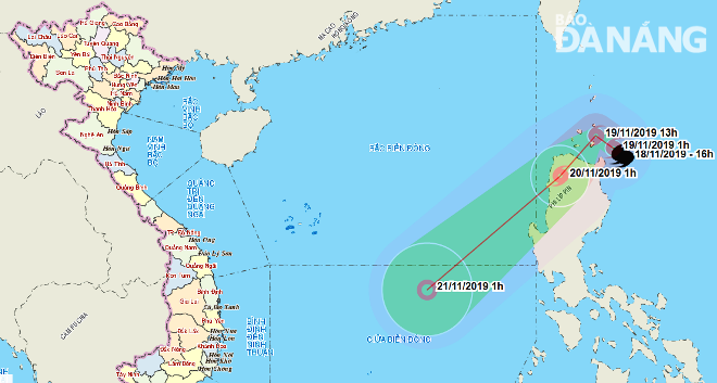
| The expected path of tropical storm Kalmaegi (Image: The Mid-Central Region Centre for Hydro-meteorological Forecasting) |
The forecasters said at 1.00pm today, 19 November, the storm was located at latitude 19°3'N and longitude 122°5'E, off the northeast coast of the Luzon Island in the Philippines, with winds near its centre at 100-115 kph and higher gusts.
Over the next 24 hours, the storm is forecast to move slowly in a southwest direction at a velocity of between 10 and 15 km an hour, and it likely to weaken into a tropical depression.
At 1.00pm tomorrow, 20 November, the depression’s position should be at latitude 16°9'N and longitude 119°9'E, off the west coast of the Luzon Island. The strongest wind speed near its centre is forecasted to be 50-60kph at levels 7-8.
Due to the effects from a cold front, starting from this evening will see scattered to moderate showers, and strong winds at level 3 thoughout the mid-central region, including Da Nang. Meanwhile, the coastal areas will experience north-easterly winds at level 6/7, and rough seas.
By Hoang Hiep - Translated by Mai Dung