Phanfone likely to weaken into depression after entering East Sea
The storm named Phanfone entered the East Sea on Wednesday evening, becoming the 8th one to hit the sea so far this year, according to the National Centre for Hydro-Meteorological Forecasting.
 |
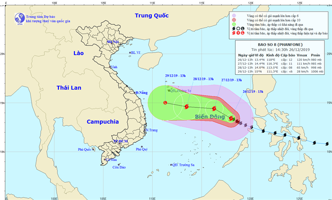
| The predicted path of the storm (Image: the National Centre for Hydro-Meteorological Forecasting) |
At 1pm today, 26 December, the storm was at latitude 13°4’N and longitude 118°0’E, about 450km east northeast of the Song Tu Tay Island, part of the Truong Sa (Spratly) archipelago. The strongest wind speed of level 8 near its centre was between 115 kph and 135kph.
In the next 24 hours, the storm is forecast to move mainly west-northwest at a speed of around 10 km per hour.
As of 1pm tomorrow, 27 December, it should be positioned at latitude 14°4’N and longitude 116°3’E, about 400km northeast of the Song Tu Tay Island, and it is predicted to carry wind speeds of between 100 and 110kph.
In the following 48 to 72 hours, the storm is likely to be weakened into a depression.
Due to the effects of the storm, since last night, the middle part of the East Sea has seen very strong winds at level 13/14, and very rough seas with 6 - 8 meter high waves.
Storm Phanfone, known in the Philippines as Ursula, has destroyed homes, cut off power and stranded travelers in the country, Reuters reported. More than 4,000 people have been evacuated in the Eastern Visayas region, although no deaths have been reported, it added.
By HOANG HIEP - Translated by MAI DUNG