Tropical depression to enter East Sea, heavy risk of thunder and showers to hit Da Nang
A tropical depression has formed in the northeast of the Philippines' Luzon Island and it will enter the East Sea in the coming days, Viet Nam's National Centre for Hydro-Meteorological Forecasting has said.
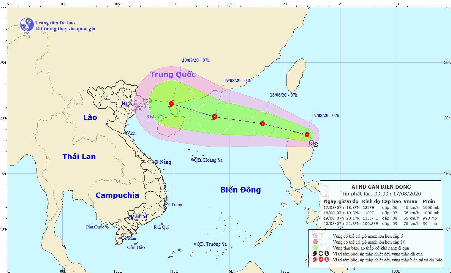 |
| The expected track of the tropical depression (Source: The National Centre for Hydro-Meteorological Forecasting) |
At 7.00am today, 17 August, the centre of the tropical depression was located at latitude 18°5'N and longitude 122°0'E, on the northern part of the Luzon Island.
The tropical depression currently has the maximum sustained winds of 40-50kph at levels 5-6, gusting up to level 8.
In the next 24 hours, the tropical depression will move in the west- northwest direction with a speed of 15 - 20 km/ hour, and head north towards the East Sea.
At 7.00am on tomorrow, 18 August, the centre of the tropical depression will be located at latitude 19°5'N and longitude 118°0'E, about 300 km north of the Luzon Island, with the strongest wind of level 9.
Over the next hours, the tropical depression is forecast to move in a west- northwest direction at a velocity of 15 - 20 km an hour, and increase its intensity to develop into a storm later.
Due to the strong influence of the tropical depression, the northern and eastern parts of the East Sea will likely to embrace for strong winds, tornadoes and rough seas.
Besides, under the influence of the ongoing tropical depression, some Vietnamese northern mountainous and midlands are bracing for moderate to heavy downpours with the average rainfall of between 40 and 80mm per day, and even over 100mm in some of their parts.
Additionally, such Vietnamese northern mountainous and midlands as Lai Chau, Dien Bien, Son La, Lao Cai, Yen Bai, Ha Giang, Thai Nguyen, Bac Kan, Quang Ninh, Lang Son, Bac Giang, Cao Bang and Tuyen Quang have been warned of possible flash floods and landslides.
There is a high risk of heavy thunder and scattered showers likely to hit localities from Da Nang to Binh Thuan, especially at night, with the potential for whirlwinds and lightning. Temperatures will ramp up to highs of between 27 and 34 degrees Celsius.
By Bao Tin Tuc - Translated by M.D