Storm Etau forecast to strike Phu Yen- Ninh Thuan coast on Tuesday
Central Viet Nam may has zero respite during this tough year as storms are lining up to make their ways to the hash weather-battered land, and tropical storm Etau is the latest.
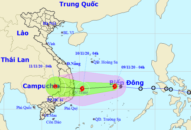 |
| Storm Etau tracking map (Photo: NCHFM) |
Etau, which evolved from a tropical depression over the East Sea on Sunday evening, proclaiming as the 12th storm to hit Viet Nam this year, and is heading for south- central Viet Nam, Viet Nam’s National Center for Hydro-meteorology Forecasting (NCHFM) said in its latest bulletin.
At 4.00 am today, on 9 November, the centre of Etau lay around latitude 13°0’N and longitude 114°7’E, about 180km north of the Song Tu Tay (Southwest Cay) Islet, packing with the strongest sustained winds of level 8, with a gale of level 10. The wind radius of the storm is 110km wide.
At 4.00am tomorrow, 10 November, the storm is projected to be about 120 km east of the coast off localities from Phu Yen to Ninh Thuan, bringing up with the maximum winds of level 9, a gale of level 11.
In the next 24 - 48 hours, Etau will have a high likelihood of travelling westward at a velocity of about 15kph, moving over the land of the aforementioned south central localities, and gradually weakening into a tropical depression, then a post-tropical low remnant after that, and finally, dissipating.
By 4.00am on Wednesday, 11 November, the remnants of the storm are expected to make its berth above eastern Cambodia, with the strongest winds dropping significantly to below level 6.
From tomorrow, 10 November, onwards, the waters off the region from Quang Ngai to Ninh Thuan provinces will brace for strong winds of levels 6 - 7, and a gusty gale of level 11 near the storm’s centre, along with very rough sea and 3-5m high waves.
Due to the combined influence of the storm’s circulation and a cold front, from Monday afternoon into to Thursday, 12 November, the parts from Quang Tri to northern Khanh Hoa will be heavily got soaked with the total average rainfall of 200-400mm, even over 400mm in some places.
Likewise, the lesser rain accumulation hovering at 100-200mm will be measured in Quang Binh, southern Khanh Hoa and Central Highlands will see common rainfall 100-200mm.
This weekend and subsequent days, Da Nang is forecast to see cloudy and soaking weather with scattered showers in some of its parts. Its thermometers should kept unchanged at between 21 to 28 degrees Celsius in the daytime, and turn a bit chilly in the night time.
Meanwhile, a new tropical depression has appeared over the waters to the east of the Philippines, and it is highly likely to enter the East Sea on Thursday, 12 November, and then make a jump in intensity to become the 13th storm to hit Viet Nam this year.
By HOANG HIEP- Translated by AT