Storm Goni changes course to head for Quang Ngai- Khanh Hoa on 5 Nov.
Storm Goni has changed direction, it is now on a collision course with the south central coast, according to Viet Nam's National Hydrology Meteorology Forecast Centre (NCHFM)’s latest watches and warnings.
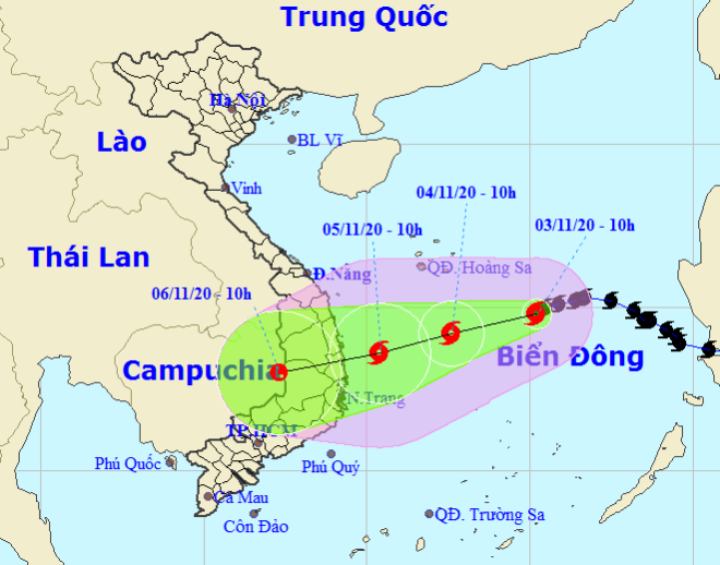 |
| Storm Goni tracking map (Photo: NCHFM) |
The storm is forecast to make landfallmake anywhere from Quang Ngai- Khanh Hoa on Thursday, 5 November, and it is then likely to weaken into a tropical depression as it moves over the land.
Although Goni has no longer been a super typhoon, it remains a powerful storm with complicated developments, prompting Vietnamese and international weather services to make different predictions about its range of impacts.
NCHFM said, at 4.00am on Wednesday, 4 November, the centre of Goni will be located near latitude 14°3’N and longitude 113°2’E, about 290 km southeast of the Hoang Sa Archipelago with maximum sustained winds near the centre falling a bit to levels 8-9 (60-90 pkh), with a gust of level 11.
In the next 24 – 48 hours, Goni will move the west-southwestward at lower pace westward at only 10kph.
At 7.00am on Thursday, on 5 November, the storm is expected to reach the area of sea about 150 km east of coast from Quang Ngai to Khanh Hoa, with its gusty wind intensity may keep unchanged.
In the next hours to come, the storm will move into the mainland of these aforementioned localities before downgrading its strengths into post-tropical remnant low.
Based on these above predicts, Da Nang and Quang Nam, to the north of Quang Ngai, are not directly threatened by this storm unlike forecast earlier.
Previously, Japanese weather forecasters said that Goni would make landfall in Viet Nam on Wednesday, 4 November and has a 70% chance of affecting a vast region running from central Ha Tinh Province to localities in the south.
Also, some international weather services made different forecasts about the storm’s intensity when it makes a landfall in Central Viet Nam, which could range between levels 9 - 10.
Meanwhile, Truong Ba Kien from the Viet Nam Institute of Meteorology, Hydrology and Climate Change forecast that Goni could change its direction many times and move slower than the previous typhoon Molave.
By HOANG HIEP- Chinhphu.vn- Translated by A.T