Low-pressure system brings rain to Da Nang, other mid-central localities over next 3 days
Da Nang and elsewhere in the mid-central region are forecast to brace for widespread heavy downpours from June 12 to 14 under the impact of the ongoing low-pressure system northeastern of the Hoang Sa (Paracel) Archipelago, the Mid-Central Region Centre for Hydro-meteorological Forecasting said in its latest bulletin.
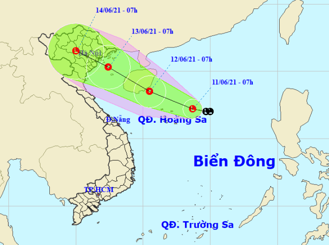 |
| The expected track of the ongoing low-pressure system (Source: The National Centre for Hydro-Meteorological Forecasting) |
In Da Nang alone, this evening is predicted to see scattered showers accompanied with thunderstorms, lightning and strong winds.
Over the next 3 days, showers, thunderstorms and strong gusts are highly likely to be reported in the waters off mid-central localities from Quang Binh to Quang Ngai and the Hoang Sa islands.
For the time being, the low pressure system, which was formed northeastern of the Hoang Sa Archipelago, is moving northwestwards at a speed of 15km/h and is highly likely to strengthen into a tropical depression.
At 7:00am tomorrow, June 12, the centre of the tropical depression is projected to be near altitude 18°5’N and longitude 110°5’E altitude, southeast of China’s Hainan Island, packing with the strongest sustained winds of levels 6,7, with a gale of level 9.
In order to proactively respond to new tropical depression and possible widespread downpours, the Steering Committee of Natural Disaster Mitigation, Search and Rescue and Civil Defence is urging functional local agencies to inform local fishing boats of the predicted movement of the tropical depression, hereby allow them to take the initiative to avoid dangerous areas or seek safe shelters.
Reporting by HOANG HIEP- Translating by A.T