Tropical depression enters East Sea and gets stronger
A tropical depression is entering the East Sea and is getting stronger, Viet Nam’s National Center for Hydro-meteorological Forecasting (NCHMF) has said.
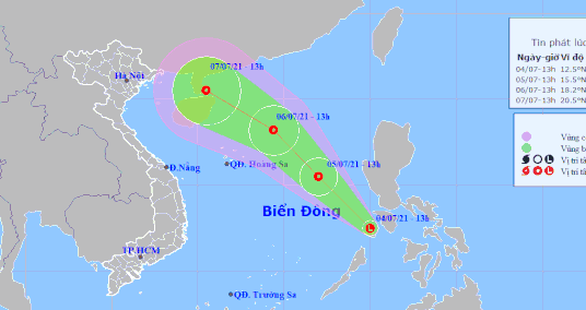 |
| The forecast track of the tropical depression (Source: NCHMF) |
Today (July 5) at 1 pm, the center of the tropical depression is likely located about 550km southeast of the Hoang Sa (Paracel) Islands with the maximum sustained winds reaching level 6, and the gusts as high as level 8. The system is moving northwestward in the East Sea at 15-20kmph and continues to gain strength.
At 1pm tomorrow 9 (July 6), the depression center expects to track to 240km northeast of the Hoang Sa Islands with the maximum sustained winds reaching level 7, and the gusts as high as level 9.
Monday into Wednesday, offshore area stretching from Binh Thuan to Ca Mau will see gradually increasing the southwest wind at level 5-6, and the gusts reaching level 7-8, and experience rough seas with waves as high as 2-3m. In addition, showers and thunderstorms will be possible in the area between the East Sea and the South of the East Sea (including the waters of the Truong Sa Archipelago), offshore area stretching from Binh Dinh to Ca Mau, from Ca Mau to Kien Giang and the Gulf of Thailand.
Reporting by HOANG HIEP – translating by H.L