East Sea-formed low pressure area gains intensity, brings widespread heavy rain to Central Viet Nam
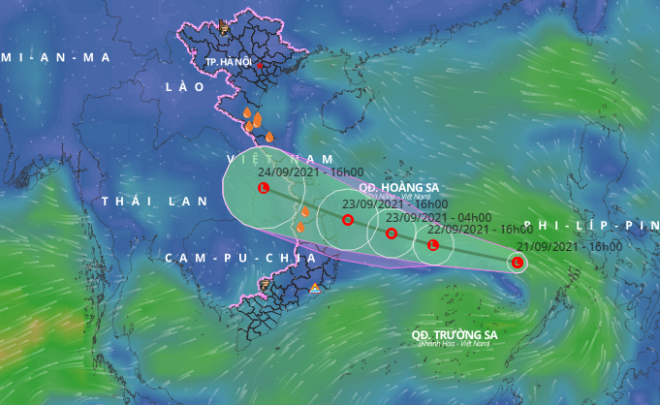
Under the influence of a tropical convergence zone connected to a low pressure area in the middle of the East Sea which is likely to strengthen into a tropical depression soon, heavy downpours are expected to lash throughout central localities from Quang Binh to Quang Ngai, including Da Nang, from Wednesday afternoon till Saturday, September 25.
 |
| The expected track of the low pressure area recently formed in the East Sea. Photo courtesy of the Viet Nam Disaster Monitoring System |
On early morning of September 22, the low pressure area’s centre was positioned at 250km northeast of the Song Tu Tay Island, the Mid-Central Region Centre for Hydro-meteorological Forecasting said.
For the time being, the low pressure area is travelling northwest at a velocity of 10-15km per hour. Afterwards, it is forecast to move faster at a 15-20km per hour with growing intensity to then strengthen into a tropical depression.
From this afternoon and tonight, September 22, central localities from Quang Binh to Quang Ngai will be projected to brace for scattered moderate and heavy downpours and thunderstorms with a rainfall of 10-30mm per session, and even more than 50mm in some certain places.
Of special note, during a possible thunderstorm, it is necessary to watch out for lightning and strong gusts.
From September 23 - 25, there is a high possibility of heavy rain on a large scale in localities in the Mid-central region.
Da Nang, from September 23 – 27, is highly likely to see cloudy, some scattered shower accompanied with thunderstorm in some of its parts, says Viet Nam's National Center for Hydro-meteorological Forecasting (NCHF). The mercury will hover at 24 – 33 degrees Celsius,
Reporting by HOANG HIEP – Translating by A.T