Storm brings heavy rains to Da Nang, expected to weaken into depression after lanfall
Localities from Quang Tri to Binh Dinh experienced heavy to very heavy rains from morning to noon today, September 23, with a common rainfall of 40-80mm and more than 120mm in some place as the depression on Wednesday afternoon strengthened into a storm which has become storm No. 6 so far this year. Torrential rains left some streets in Da Nang under water in the noon hours.
 |
| Heavy rains flood an area at the intersection of Ong Ich Khiem - Le Duan streets in the noon hours on September 23. Photo: HOANG HIEP |
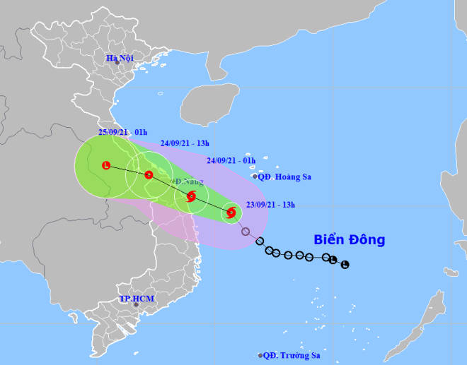
In its latest bulletin, Viet Nam’s National Centre for Hydro-Meteorological Forecasting said at 1:00pm on Thursday, September 23, the storm's centre was located at latitude 14°7'N and longitude 110°7'E, about 330km from the coast off Quang Nam province and about 380k from the coast off Da Nang, packing maximum sustained winds at level 8 and gustiness of up to level 10.
The radius of strong winds from level 6 and gusts from level 8 upwards is about 120km from the storm’s centre.
In the next 24 hours, the storm will move toward the west-southwest at 15-20km per hour.
At 1:00 am on Friday, September 24, the storm will be positioned near latitude 15°4 'N and longitude 109 °E, right in the waters off the parts from Thua Thien Hue to Quang Ngai, with the maximum sustained winds reaching level 8, and the gusts as high as level 10.
The storm will continue to move toward the west-southwest at 15-20km per hour and make landfall in the parts from Thua Thien Hue to Quang Ngai, and then weaken into a tropical depression.
 |
| Expected track of the storm (Source: Viet Nam’s National Centre for Hydro-Meteorological Forecasting) |
The offshore area stretching from Quang Tri to Binh Dinh (including Con Co, Ly Son and Cham islands),will see gradually increasing the southwest wind at level 6-7, and the gusts reaching level 8-10, and experience rough seas with waves as high as 2-4m.
During the afternoon and evening hours on September 23, the parts from Quang Tri to Quang Ngai will see strong winds at level 6-8 while the parts from Thua Thien Hue to Quang Nam will experience strong winds at level 6- 7 and their coastal areas will see storm-force winds at level 8 with the gusts as high as level 10.
Thursday afternoon into Friday, September 24, it will rain very strong in the parts from Ha Tinh to Binh Dinh with a common rainfall of 150-250mm, and forecasters warning up to 300 mm could fall in some places.
Forecasters have also issued warnings of flash floods and landslides for mountainous areas, and flooding alerts are in place in low-lying areas and riverside areas.
 |
| Workers of the Da Nang Drainage and Wastewater Treatment Company diverting rainwater in order to prevent flooding at the intersection of Le Dinh Ly - Nguyen Van Linh - Ham Nghi streets. Photo: HOANG HIEP |
Reporting by HOANG HIEP – Translating by H.L