Storm Conson weakens into tropical depression, bringing heavy rains to central localities
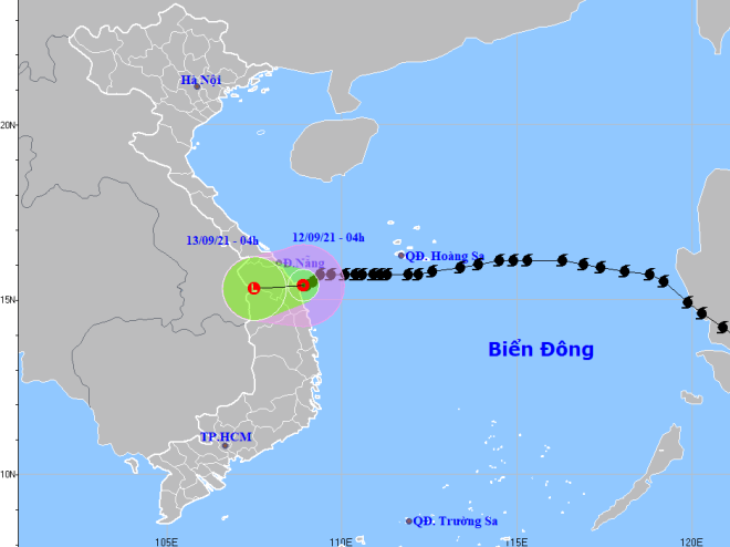
At dawn on Sunday, September 12, storm Conson weakened into a tropical depression before hitting the coast off Binh Son District, Quang Ngai Province, bearing the strongest winds level reducing to level 6 and gusts of level 8. The radius of strong winds from level 6 and gusts from level 8 upwards is about 80 km from the tropical depression’s centre.
 |
| The expected track of the tropical depression (Source: The National Centre for Hydro-Meteorological Forecasting) |
According to the National Centre for Hydro-Meteorological Forecasting (NCHFM), the tropical depression is moving westward at a velocity of about 5 kph while moving inland, and then downgrade into a post-tropical remnant low over southern Laos with the strongest winds dropping below level 6.
Due to the influence of the tropical depression, the waters off localities from Thua Thien- Hue to Quang Ngai (including the island districts of Ly Son, Con Co, Cu Lao Cham) on Sunday morning braced for strong winds at levels 6-7 and gusts blowing at level 9, very rough sea and 2 - 4m high waves.
For the rest of Sunday, provinces from Quang Tri to Quang Ngai are experiencing heavy rains of up to 150 mm and over 200 mm in some places. Meanwhile, Binh Dinh, Gia Lai and Kon Tum provinces are witnessing milder rains of up to 100 mm and over 150 mm in some places.
Scattered rain is expected to engulf Da Nang tomorrow, September 13,and it will see the average mercury hover at 25-30 degrees Celsius in many of its parts.
After Typhoon Conson, six to eight other storms and tropical depressions are likely to appear in the East Sea this year, of which two to four will directly affect Viet Nam, meteorologists have warned.
Reporting by HOANG HIEP – Translating by A.T