Tropical depression likely to strengthen into storm, proactive response to heavy rain and flooding needed
A freshly-formed tropical depression is highly likely to strengthen into a storm, mainly moving in the northwestern track, entering the waters off Thua Thien Hue - Binh Dinh localities on Thursday afternoon, September 23.
 |
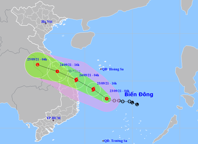
| The expected track of the tropical depression (Photo: NCHF) |
According to the Viet Nam's National Center for Hydro-meteorological Forecasting (NCHF), at 4:00am on September 23, the tropical depression’s centre was positioned at latitude 13°1'N and longitude 112°3'E, about 330km from the coast off the south-central province of Phu Yen, about 340km from the coast off Binh Dinh and about 560km from the coast off Da Nang with maximum sustained winds at level 7 and gusty gales blowing at level 9.
The radius of strong winds from level 6 and gusts from level 8 upwards is about 100km from the tropical depression’s centre.
For the time being, the tropical depression is gaining up its intensity to then strengthen into a storm, which is forecast to mainly move northwest at a velocity of 15 - 20km/h.
At 4:00am on September 24, the storm's centre is highly likely to be at about at latitude 15°1'N and longitude 109°1'E, right over the wasters off Thua Thien Hue -Binh Dinh localities, 30km from the Ly Son Island District off Quang Ngai Province and 150km from Quy Nhon City with the strongest winds at level 8 and gusts at level 10.
The storm is predicted to travel west-northwest at a velocity of 15 - 20km/h, entering Thua Thien Hue - Binh Dinh localities and gradually weaken into a tropical depression and then downgrade into a post-tropical remnant low over central and southern Laos.
Under the influence of the current tropical depression, from the afternoon of September 23, the waters off Quang Tri - Binh Dinh localities, including the island districts of Con Co, Ly Son and Cu Lao Cham, will experience strong winds at levels 6 – 7, which will gain in strengths, along with 2 - 4m high waves and very rough sea.
From evening and tonight, September 23, the mainland from Quang Tri - Binh Dinh localities will brace for strong gusts at levels 6 – 8.
From today to tomorrow, Ha Tinh - Binh Dinh localities will brace for heavy to very heavy rain accompanied by thunderstorms with a common rainfall of 150 - 250mm, and even more than 300mm in some places. The Kon Tum and Gia Lai provinces will see an amount of 100 - 200mm, and over 250mm in some places.
There is a high risk of flash floods and landslides in mountainous areas and partial flooding in low-lying and riverside areas.
The National Steering Committee for Natural Disaster Prevention and Control Committee has just urged localities to take measures to ensure safety for vessels from the growing tropical depression. Focus must be placed on calculating and calling on all fishing ships operating in areas to move out of the potentially dangerous areas or seek shelter.
Reporting by HOANG HIEP- Translating by A.T