Typhoon Conson changed direction, Da Nang deploys response measures
Typhoon Conson, Viet Nam’s the fifth storm this year, is gaining higher speed and stronger sustained winds. It is expected to be right on the Hoang Sa (Paracel) archipelago, bearing the maximum sustained winds at level 9 with a gust of level 11, according to projections recently released by the Mid-Central Region Centre for Hydro-meteorological Forecasting (NCHFM).
 |
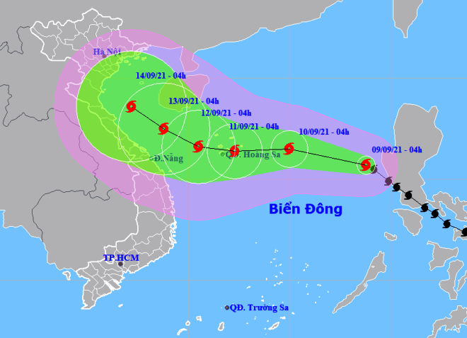
| The expected track of Conson (Source: The National Centre for Hydro-Meteorological Forecasting) |
In the morning of September 9, the typhoon’s centre was positioned at about 780km south-southeast of the Hoang Sa Islands with the strongest wind at level 9 and a gust at level 11. Conson is now on track to travel northwestward at a velocity of 15-20km/h and is likely to get stronger.
At 4:00am on September 10, the typhoon’s centre is forecast to be about 350km to the east of the Hoang Sa archipelago, packing with maximum sustained winds at level 10, with a gale blowing at up level 12.
Afterwards, it will have a high likelihood of moving westward at a velocity of 10-15km/h and is likely to gain intensity.
At 4:00am on September 11, Conson’s location is likely to be right above the Hoang Sa archipelago with the strongest winds at level 11, and a gust at level 13.
At 4:00am on September 12, Conson is expected to be centred at about 150km to the west of the Hoang Sa Islands with the maximum sustained winds at level 11, with a gusty gale at level 13, and then change the path to move in the northwestern course at a velocity of 5-10km/h.
Due to the influence of the typhoon, the eastern and central parts of the East Sea are projected to experience gales at levels 7 – 8, with the level climbing to up to 12, very rough sea and 4 - 6m high waves in the area near the storm’ centre.
Experts have warned that fishermen and boatmen need to closely follow the typhoon development, as well as observe the sky and water surface to identify abnormalities of the weather.
In order to proactively respond to the new typhoon and possible widespread downpours, Da Nang’s functional agencies are promptly informing local fishing boats of Conson’s predicted movement hereby allowing them to take the initiative to avoid dangerous areas or seek safe shelters.
As reported, 9 Da Nang fishing vessels are operating in the Gulf of Tonkin and the Bach Long Vi Island and 15 others are conducting fishing activities in the northern part of the East Sea and the Hoang Sa waters.
Scattered rain is expected to engulf Da Nang tomorrow, September 10. in the next 3 days, the city will see the average mercury hover at 25-33 degrees Celsius in many of its parts.
According to the National Centre of Hydro-Meteorological Forecasting, 6 - 8 typhoons or tropical depressions are forecast to hit the East Sea this year, including 2 - 4 directly affecting the mainland.
Provinces and cities in the central and south-central regions need to prepare for heavy rain in October, November and the first half of December, however, there is little chance of particularly heavy downpours like in 2020.
The cold weather will likely start to occur in the country earlier, from the end of September and the beginning of October.
Severe cold spells may occur around mid-December, while in previous years, they appeared in the last days of December.
In September, floods will occur downstream of major rivers in the north-central region. On small rivers and streams, in Central Viet Nam and Central Highlands, there is a possibility of flash floods and landslides. Northern balanced areas are also wary of flooding and landslides.
By HOANG HIEP- Translated by A.T