Da Nang's proactive response to heavy rainfall caused by approaching depression with pontential to become a storm
Since the early morning of October 6, Da Nang has experienced heavy rainfall triggered by the newly-developed tropical depression that is lying over the East Sea. The Da Nang Steering Committee for Disaster Response and Search and Rescue is urging authorities at local level and relevant agencies to take proactive and necessary mitigative measures in response to heavy rainfalls under the influence of the tropical depression. All vessels are banned from going to sea and are asked to find shelter in order to stay safe during severe weather.
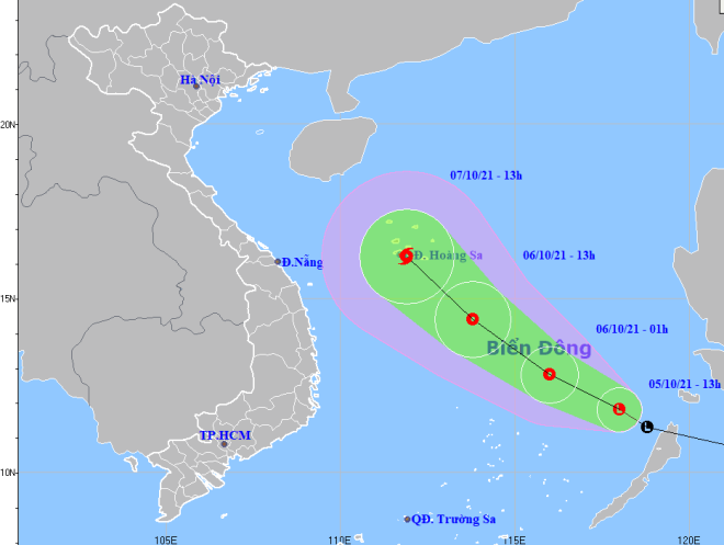 |
| The expected track of the newly-developed tropical depression storm with the potential to become a storm (Source: Viet Nam’s National Centre for Hydro-Meteorological Forecasting) |
In its latest bulletin, Viet Nam’s National Centre for Hydro-Meteorological Forecasting said at 7:00 am on October 6, the depression was located about 270km north-east of Song Tu Tay Island of Truong Sa (Spratly) Islands, packing maximum sustained winds at level 6 and gustiness of up to level 8.
The radius of strong winds at level 6 and the gusts as high as level 8 is about 100km from the tropical depression’s centre.
The tropical depression will continue to move toward the west-southwest at 20km per hour and it is expected to grow even stronger.
At 7:00 am on October 7, the depression will sit over the waters off the southern coast of Hoang Sa (Paracel) Islands, with the maximum sustained winds reaching level 7, and the gusts as high as level 9.
The tropical depression will continue to move toward the west-southwest with velocity at 10-15km per hour, and it will continue to strengthen and is expected to build into a tropical storm.
At 7:00 am on October 8, the newly-developed storm's center will be positioned at latitude 16°3'N and longitude 109°5'E, about 240km west of the Hoang Sa Islands, packing maximum sustained winds at level 8-9and gustiness of up to level 11. The storm will then move slowly toward the west-southwest with velocity at 5-10km per hour.
Due to the influence of the tropical depression with the potential to become a storm, the south of the Gulf of Tonkin, the offshore areas stretching from Quang Tri to Ca Mau, Ca Mau to Kien Giang, the Gulf of Thailand, and the East Sea (including the waters of the Hoang Sa and Truong Sa islands) are expected to experience showers and severe thunderstorms. A tornado and strong wind watch has been issued for these areas by the national forecasters.
From Wednesday into Friday, the parts from Quang Binh to Phu Yen and the north of Central Highlands will brace for heavy to very heavy rain with a common rainfall of 300-500mm in the parts from Quang Binh to Quang Ngai and Kon Tum, and even more than 600mm in some places. The parts from from Binh Dinh to Phu Yen and Gia Lai will see a common rainfall of 100-300mm, and forecasters warning up to 250mm could fall in some places.
Widespread heavy rainfall is expected across the Northern Central Coastal Region and the Northern Delta from October 9-12.
Mountainous areas could face flood warnings and potential landslides and local flooding alerts have been issued for low-lying areas.
On the evening of October 5, the Da Nang Steering Committee for Disaster Response and Search and Rescue urged heads of departments and agencies, chairmen of district-level people's committees to keep a close watch as well as prepare an effective evacuation plan to move people living in low-lying areas, along rivers and streams and areas at high risk of flash floods and landslides to safe places with proper precautions against COVID-19 in place.
Forecasters have also issued warnings of flash floods and landslides for mountainous areas, and localized flooding alerts are in place in low-lying areas and riverside areas.
The Da Nang Steering Committee for Natural Disaster Prevention and Control on Sunday morning urged authorities at local level and relevant agencies to take proactive action to create their emergency response planning for heavy rain risks tailored to their local areas.
The Da Nang Border Guard Command and Da Nang Coastal Information Station will keep a close watch on tropical depression development and progress, and keep owners of vessels operating at sea timely informed about severe weather conditions in order to help them avoid the bad weather.
The health agency will work with the Da Nang Border Guard Command, the authorities in Son Tra District, the authority of the Tho Quang Fishing Wharf conduct COVID-19 testing for all crew members of fishing boats which dock at the Tho Quang Port for finding a safe shelter during the severe weather in order to timely detect and isolate those with suspected or confirmed COVID-19 to prevent the spread of the virus.
Authorities at local level must assist their residents to prepare for severe weather in an attempt to keep them safe. In addition, all necessary measures are needed to move people living in low-lying areas, along rivers and streams and areas at high risk of flash floods and landslides to safe places with proper precautions against COVID-19 in place.
Besides, the heed is paid on providing guidance and advice for construction sites to prepare for severe weather.
Reporting by HOANG HIEP – Translating by H.L