Flood warnings issued for rivers in Central Viet Nam
Viet Nam’s National Center for Hydro-meteorological Forecasting has stated that there is a significant risk of potential flooding from rivers in the parts from Thua Thien- Hue to Binh Thuan, Central Highlands and the upstream of Dong Nai River in the southeast region from Tuesday into Thursday. The water level on rivers from the parts from Thua Thien- Hue to Khanh Hoa, and the north of Central Highlands is likely to hit its peak to reach at alert level 1 to level 2 or above.
At 8:30 am today, October 26, the Song Tranh 2 hydropower plant was asked by the Quang Nam authorities to reduce its water level at the lowest possible level to enable its reservoir to receive floodwaters from Thu Bon River downstream in the coming days as much as they can, and it must be completed before 8:30 am on October 28. Discharges from the reservoir into Thu Bon River are required to increase by 400-600m3/s compared to the amount of floodwaters flowing into it.
Earlier at 2:00pm on October 25, discharges from reservoir of the Dak Mi 4 hydropower plant into the downstream of the Vu Gia River were 250-350m3/s higher than the amount of floodwaters flowing into it.
The Bung 2, Bung 4 and A Vuong hydropower plants are ready to switch to operate for flood reduction in the downstream of the Vu Gia River.
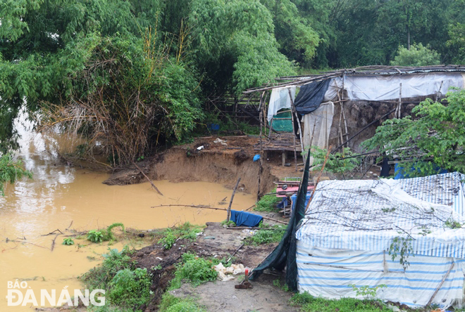 |
| Water levels have remained high on the Yen River for the past one month because of continuous heavy rains and discharges from reservoirs of hydropower plants, causing some parts of riverbanks to be eroded. Photo: HOANG HIEP |
In its latest bulletin, Viet Nam’s National Centre for Hydro-Meteorological Forecasting said at 9:00am today, October 26, the newly-formed tropical depression was positioned at latitude 11°2'N and longitude 111°5'E, about 280km off the coast of Khanh Hoa, and 258km off the coast of Ninh Thuan, with the maximum sustained winds reaching level 6-7, and the gusts as high as level 9.
The depression is expected to move generally westward at about 15 km per hour.
The depression will move farther inland over the parts from Khanh Hoa to Binh Thuan while weakening, and it is likely to downgrade to a remnant low pressure system over the southern part of Central Highlands.
Tuesday into Wednesday, heavy to very heavy rainfall and thunderstorms are predicted for the parts from Thua Thien- Hue to Binh Thuan, including Da Nang, Central Highlands and the southeast region. Rainfall warnings have been issued for a widespread soaking rain that could dump as much as 100mm-200mm of rain over parts from Thua Thien- Hue to Quang Ngai, Binh Thuan, the north of Central Highlands and the southeast region while more than 200mm of rain could fall in some places. The total rainfall amount will be 150mm - 250mm in common in the parts from Binh Dinh to Ninh Thuan and the South of Central Highlands, and even more than 300mm in some places.
Forecasters have also warned that North Central Coast and Mid-central Region could continue to witness heavy rainfall from Wednesday into Saturday with possibility of very heavy rains in some places due to the combined influence of cold air and easterly winds.
Forecasters have also issued warnings of flash floods and landslides for mountainous areas, and flooding alerts are in place in low-lying and riverside areas and urban areas in the parts from Thua Thien- Hue to Binh Thuan, Dong Nai and Central Highlands.
Reporting by HOANG HIEP – Translating by H.L