Low-pressure system expected to become storm, bringing widespread thunderstorms to Da Nang
A low pressure system in the south of Philippines has passed through the Philippines's Palawan Island, and it moved into the East Sea on Tuesday morning, October 5. Widespread rain and thunderstorms are predicted across Central Viet Nam, including Da Nang, from Tuesday into Thursday, October 7.
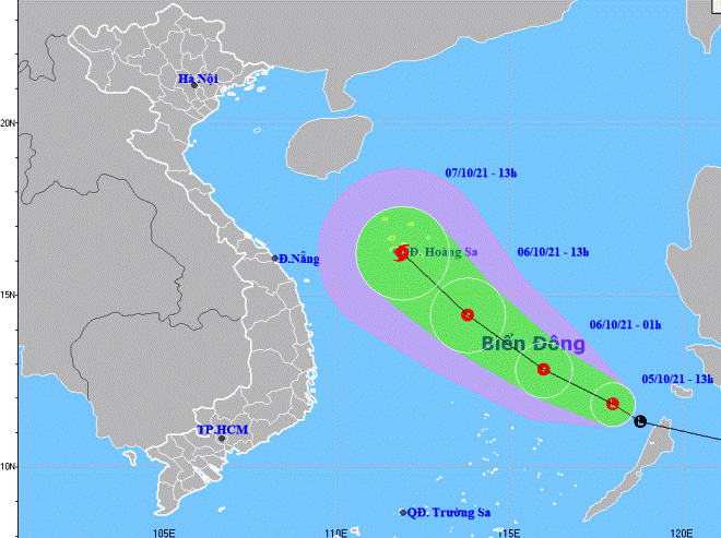 |
| The expected track of the low pressure area (Source: Viet Nam’s National Centre for Hydro-Meteorological Forecasting) |
In its latest bulletin, Viet Nam’s National Centre for Hydro-Meteorological Forecasting said at 1:00pm on Tuesday, October 5, the center of the low pressure system was located about 410km east of Song Tu Tay Island of Truong Sa Islands.
In the next 12 hours, the low pressure system will move toward the west-southwest at 20km per hour, and this system could become a tropical depression while it changes its direction toward the northwest with velocity at about 20- 5km per hour. The newly-formed depression is expected to grow even stronger.
At 1:00pm on October 6, the depression will be positioned about 330km southeast of Hoang Sa Islands, packing maximum sustained winds at level 7 and gustiness of up to level 9. The tropical depression will continue to move toward the northwest with velocity at 10-15km per hour, and it will continue to strengthen and is expected to build into a tropical storm.
At 1:00pm on October 7, the newly-formed storm's centre will be right in the Hoang Sa Islands, with the maximum sustained winds reaching level 8-9, and the gusts as high as level 11.
From tonight ,October 5, the area between the East Sea and the land will see gradually increasing the southwest wind at level 6-7, and the gusts reaching level 9, and experience rough seas with waves as high as 2-4m.
The South of the East Sea will see gradually increasing the southwest wind at level 5-6, and experience rough seas with waves as high as 1.5-2.5m.
The Gulf of Tonkin, the offshore areas stretching from Quang Tri to Ca Mau, Ca Mau to Kien Giang, the Gulf of Thailand, and the East Sea (including the waters of the Hoang Sa and Truong Sa islands are expected to experience showers and severe thunderstorms. A tornado watch has been issued for these areas by the national forecasters.
Widespread rainfall is expected across Central Viet Nam from Tuesday into Thursday, according to the Mid-Central Region Centre for Hydro-meteorological Forecasting.
The parts from Quang Binh to Thua Thien will see moderate rainfall from Tuesday into Wednesday, heavy to very heavy rains and thunderstorms in some places with a common rainfall of 25-50 mm, and forecasters warning up to 70mm could fall in some places.
During the late afternoon and night hours, the parts from Da Nang to Quang Ngai will witness showers and thunderstorms, along with localized moderate to heavy rainfall from Tuesday into Thursday, with a common rainfall of 20-40mm, and forecasters warning up to 50mm could fall in some places. Forecasters have also issued warnings of lightning, strong wind gusts and possible tornadoes for these parts.
Reporting by HOANG HIEP – Translating by H.L