Storm No.8 likely to weaken into tropical depression before landfall
Storm No. 8 moved into the Gulf of Tonkin on Wednesday night, October 14. The storm will continue to move quickly westward while gradually weakening. It is expected to downgrade to a tropical depression before making landfall over the parts from Thanh Hoa to Quang Binh.
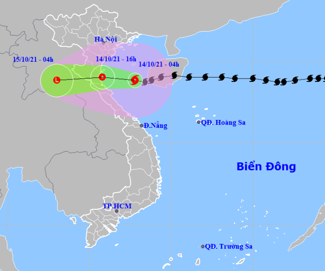 |
| The expected track of the storm No. 8 (Source: Viet Nam’s National Centre for Hydro-Meteorological Forecasting) |
In its latest bulletin, Viet Nam’s National Centre for Hydro-Meteorological Forecasting said at 7:00 am, today, on October 14, the storm No. 8 was spotted at latitude 19°N and longitude 107°5,' about 205 km off the coast of Thanh Hoa. about 203 km off the coast of Nghe An, about 190 km off the coast of Ha Tinh. It had maximum sustained winds at level 7, and gustiness of up to level 9.
The storm will continue to move slowly west at 10 km per hour, and it is likely weaken into a tropical depression thereafter.
The depression will move farther inland over the parts from Thanh Hoa to Quang Binh while weakening and it is likely to downgrade to a remnant low pressure thereafter.
Thursday into Friday, moderate to heavy rainfall are predicted for the northern region and Quang Tri and very heavy rain is likely to occur in some places. A heavy to very heavy rainfall alert are given toThanh Hoa to Quang Binh.
Forecasters have also issued warnings of flash floods and landslides for mountainous areas, and localized flooding alerts are in place in low-lying areas and riverside areas.
Heavy to very heavy rainfall are forecast for Central Viet Nam from October 16 into October 19 due to the effect of intensification of the cold front and the intertropical convergence zone.
Reporting by HOANG HIEP – Translating by H.L