Yen and Cam Le rivers burst banks, roof blown off of 17 Da Nang homes by tornado
Heavy downpours have caused Yen and Cam Le rivers to burst their banks, leaving some low-lying roads flooded and under 0.3-0.8m water on Thursday morning, October 28.
The roof was completely blown off 4 houses and partially ripped off 13 others, 5 barns were destroyed and 2 power poles fell down after the tornado touched down in Phu Son Tay Village, Hoa Khuong Commune, Hoa Vang District on Wednesday afternoon, October 27.
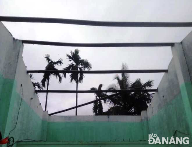 |
| The tornado blew the roof off a house in Phu Son Tay Village, Hoa Khuong Commune, Hoa Vang District on the afternoon of October 27. Photo: PV |
At 4:00 am today, October 28, water levels on the Vu Gia River at the part of the Ai Nghia Hydrological Station reached 7.99m, just 1cm below alarm level 2 as a result of heavy rains.
Floodwaters flowing from the Vu Gia River have caused the upstream of the An Trach Dam on the Yen River to overflow, sending a large amount of water to flood some low-lying riverside roads, especially the low-lying road connecting Hoa Tien Commune to Dien Tien Commune, Dien Ban Town, Quang Nam Province was under about 0.8m water.
Overflowing Cam Le River has left the low-lying section of Thang Long Street under 0.3-0.4m water.
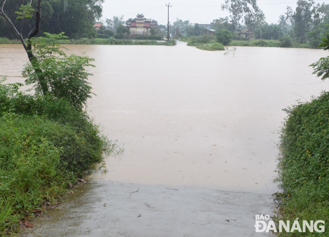 |
| The low-lying road connecting Hoa Tien Commune to Dien Tien Commune, Dien Ban Town, Quang Nam Province was under about 0.8m water after the Yen River overtopped its banks as a result of heavy rains. Picture was taken at 7:00am on October 28. Photo: HOANG HIEP |
At 7 am on October 28, discharges from reservoirs of A Vuong, Song Bung 4, Dak Mi 4 and Song Con 2 hydropower plants into the downstream of the Vu Gia River were only about 850m3/s. The water level on the Yen River is rising slowly and is expected to hit its peak at the midday on October 28.
Viet Nam’s National Center for Hydro-meteorological Forecasting has stated that there is a significant risk of potential flooding from rivers in the parts from Nghe An to Binh Dinh and the Central Highlands from Thursday into Sunday. The water level on the upstream of rivers from the parts in Ha Tinh and Quang Binh is likely to hit its peak to reach at alert level 2 to 3 while that on upstream of rivers in Nghe An and the part from Quang Tri to Binh Dinh, Central Highlands, will reach alert level 1 to 2 or above.
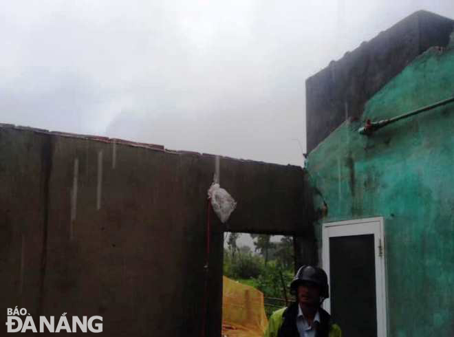 |
| The National has issued warnings of tornadoes, lightning and strong winds during thunderstorms for Central Viet Nam. In the photo: The roof of a home in Phu Son Tay Village, Hoa Khuong Commune, Hoa Vang District, Da Nang was completely blown off by the tornado. Photo: PV |
Forecasters have also warned that Central Viet Nam, including Da Nang, could continue to witness moderate to heavy rainfall from Thursday into Saturday with possibility of very heavy rains in some places due to the combined influence of cold air and easterly winds.
The total rainfall amount will be 200-350mm in common in the part Nghe An to Quang Binh while more than 400mm of rain could fall in some places.
Thursday into Friday, rainfall warnings have been issued for a widespread soaking rain that could dump as much as 100mm-120mm of rain over parts from Quang Tri to Quang Nam, including Da Nang, and even more than 180 mm in some places.
Thunderstorms are likely to occur and can produce tornadoes, lightning, hail and strong winds. Forecasters have also issued warnings of flash floods and landslides for mountainous areas, and flooding alerts are in place in low-lying and riverside areas and urban areas in the parts from from Nghe An to Khanh Hoa and Central Highlands.
Reporting by HOANG HIEP – translating by H.L