Typhoon Rai to travel parallel along central Vietnamese coast, bringing downpours, gustiness levels 7-8 to the mainland
According to the National Center for Hydro-Meteorological Forecasting, typhoon Rai, the ninth storm to hit Viet Nam this year, is now moving northward and it is expected to switch to the northeast direction, traveling parallel along the central coast.
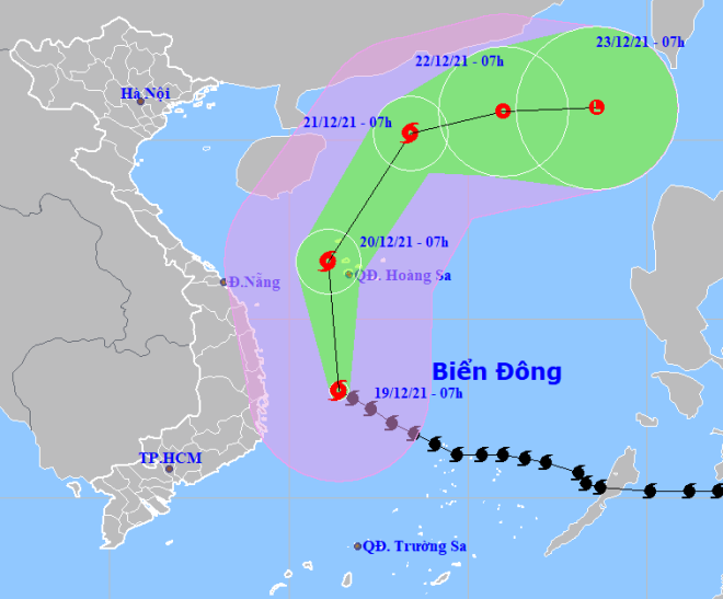 |
| The expected track of typhoon Rai (Source: The National Centre for Hydro-meteorological Forecasting) |
Rai was located 230km east of the country’s south-central region as of 7:00 am on Sunday, national forecaster said in its bulletin.
The radius of strong winds at level 6 and the gusts as high as level 8 is now about 250 km from the storm’s center.
By 7:00 a.m. on Monday, December 20, the typhoon's centre is expected to be positioned at latitude 16°6'N and longitude 111°1'E, to the west of the Hoang Sa Archipelago with the strongest winds at levels 13-14, and a gustiness of up to level 16.
After that, Rai is projected to changes its direction and move north-northeast at a velocity of 15-20km per hour.
By 7:00 a.m. on Tuesday, December 21, the typhoon’s centre is likely to be positioned about 260km southwest of Hong Kong (China) with the maximum sustained winds levels 9 -10, and the gusts as high as level 12.
Rai is forecast to be downgraded to a tropical depression in the next 48 to 72 hours, with winds at 40-50km per hour.
Due to the strong influence of typhoon Rai and cold front, medium to heavy rains are seen dampening a vast stretch from north-central Thua Thien-Hue Province to south-central Phu Yen Province.
The average rainfall is expected to be around 50 to 100 millimeters, and over 150 millimeters in some areas.
Tomorrow, December 20, the mainland of coastal localities of Thua Thien Hue, Da Nang and Quang Nam will experience strong winds of levels 5-6, with gusts of level 7, whilst coastal provinces of Quang Ngai, Binh Dinh and Phu Yen are expected to brace for strong winds of levels 6-7, and a gale of level 8.
The weather pattern will pose a high risk of flash floods, landslides, and inundation.
Before entering the East Sea on Friday afternoon, Rai had swept over the Philippines. More than 30 people are feared dead and many are missing due to this devastating storm, the BBC said.
Rai had previously intensified to a Category 5 storm, the highest classification with maximum sustained winds of at least 156 mph.
Reporting by HOANG HIEP – Translating by A. THU