Wet and cold weather set to blight Mid-central region
Typhoon Rai is rapidly strengthening east of the southern Philippines and may be on the verge of becoming a super typhoon. The storm is on track to slam the southern and central portions of the country Thursday. Rai currently has sustained winds of 215 km per hour, making it the equivalent of a Category 4 hurricane on the Saffir-Simpson wind scale.
In the Philippines, the storm is known as Odette and is being monitored locally by the Philippine Atmospheric, Geophysical and Astronomical Services Administration (PAGASA).
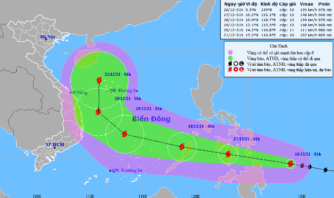 |
| The expected track of Typhoon Rai (Source: Viet Nam’s National Centre for Hydro-Meteorological Forecasting) |
In its latest bulletin, the Mid-Central Region Centre for Hydro-meteorological Forecasting said at Typhoon Rai ‘s centre was approximately 400 km south-east of the Philippines’s central coast with maximum sustained winds at level 13, gustiness of up to level 16 on Thursday morning. The storm is rapidly moving west-northwest at 25 km per hour.
At 1:00 am on December 17, Rai's centre will be will be positioned in the south of the Philippines’s central coast with packing maximum sustained winds at level 13, and the gusts as high as level 16. The storm will continue to move very quickly to west-northwest at about 20km per hour and it is expected to move into the East Sea.
At 1:00 am on December 18, the storm's centre will be about 500km southeast of Song Tu Tay Island with the maximum sustained winds reaching level 13, and the gusts as high as level 16. The storm will continue moving west-northwest at about 25km per hour.
From Friday into Sunday, showers are expected to continue lashing the parts from Quang Binh to Quang Ngai, including Da Nang, with moderate to heavy rainfall likely in some places due to the combined effects of the northeast monsoon and the developing low pressure trough associated with tropical storm Rai.
By the coast they will see strong winds at level 3 to 4 and the gusts as high as level at 5 to 6, and farther inland you could find strong winds at levels 2 to 3.
From Saturday, December 18, a cold weather snap is predicted for the parts from Quang Binh to Thua Thien Hue with temperatures expected to drop to 15-18 degrees Celsius in plains and are likely fall further to 14-17 degrees Celsius in mountainous areas. The parts from Da Nang to Quang Ngai will see chilly temperatures at night into the morning hours to drop 18-20 degrees Celsius in the plains, and 17-19 degrees Celsius in the mountains.
From Friday afternoon, December 17, the offshore areas stretching from Quang Binh to Quang Ngai, including Da Nang, could see northeast winds at level 6 and the gusts reaching levels 7 to 8, as well as experience rough seas with waves as high as 2-4m. The Hoang Sa waters will see gradually increasing northeast wind at level 7, and the gusts reaching level 8 to 9, and experience rough seas with waves as high as 3-5m.
Reporting by HOANG HIEP – translating by H.L