Alert for strong winds and high waves in coastal areas of Central Viet Nam as Nalgae moves into East Sea
The Mid- Central Region Center for Hydro-meteorological Forecasting said early Sunday morning, October 30, Severe Tropical Storm Nalgae pulled away from the southern part of Luzon Island, the Philippines, and moved into the East Sea.
Nalgae is the seventh named tropical storm that has entered the East Sea so far this year.
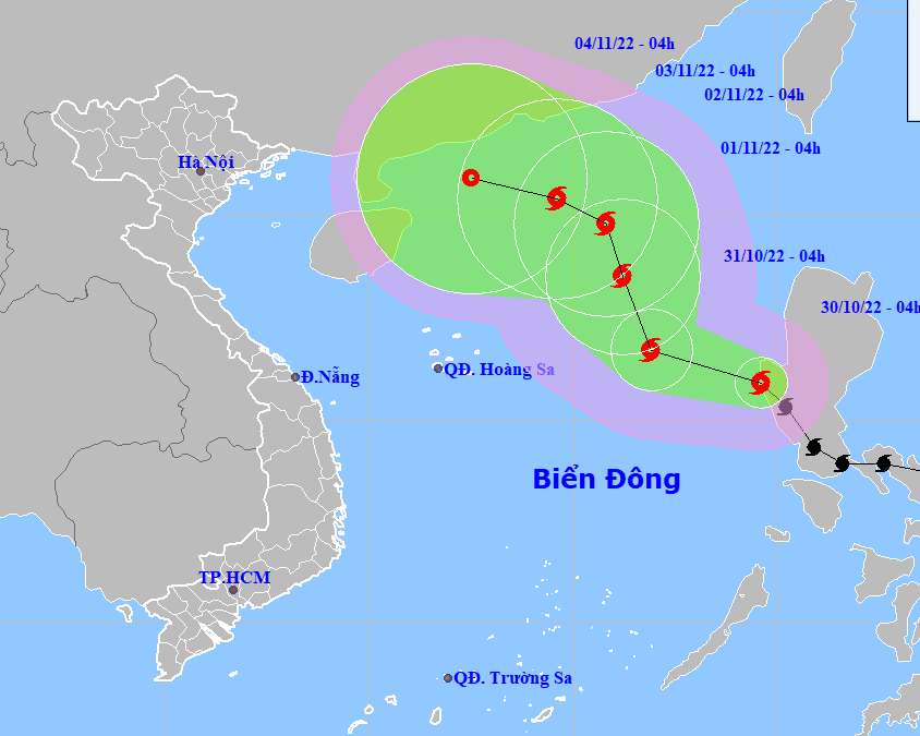 |
| Tropical Storm Nalgae latest projected path and map (Source: Viet Nam’s National Center for Hydro-meteorological Forecasting). |
Nalgae has already wreaked havoc in the Philippines, killing at least 45 people.
The regional forecasters on Sunday said the cyclone, centred near latitude 15.9 North, longitude 119.6 East at 4:00 am, sat over the Eastern part of the North and the middle of the East Sea, with the maximum sustained winds reaching level 10, and the gusts as high as level 12.
Over the next 24 hours, the regional weather service expects the storm to gain strengths in the East Sea as it moves west- northwestward at 15km per hour. At 4:00 am on Monday, October 31, the center of tropical storm Nalgae will be located near latitude 16.7 North, longitude 116.9 East, about 590km East of the Hoang Sa (Paracel Islands). Maximum sustained winds will reach levels at 10 to 11 with gusts at level 13.
The storm is expected to strengthen into a typhoon by Monday night with a sustained maximum wind speed of 120km per hour, before easing back into a severe tropical storm on Tuesday.
A turn to the north is expected on Monday as the storm cuts across the East Sea at 10km per hour. At 4:00 a.m. on Tuesday, November 1, the storm's center will be positioned near latitude 18.5 North, longitude 116.2 East, about 550km northeast of the Hoang Sa Islands, packaging maximum sustained winds reaching level 11, and the gusts as high as level 13.
Due to the influence of the storm, coastal areas in the parts from Quang Tri to Quang Ngai, including Da Nang, are seeing strong northeasterly winds reaching levels 4 to 5, and level 6 in their southern part, with gusts above level 6, and rough sea, regional regional forecasters said.
Strong northeasterly winds of level 6, gustiness of levels at 7 to 8, with rough sea and waves as high as 2m-4m are in forecast for the open waters off the Quang Tri - Quang Ngai coast on Sunday.
A warning for strong winds of levels at 7 to 8 and rough sea with waves as high as 5m-7m is issued to the North and the middle of the East Sea (including the waters of the Hoang Sa Islands) during the daytime and night hours on Monday, October 31. The storm will have maximum sustained winds reaching levels at 10 to 11 near its center with gusts of level 13 while an alert for rough sea with waves as high 7m -9m is in place for this area.
The offshore area stretching from Quang Tri to Ca Mau, including Da Nang, will see high winds reaching level 6, sometimes increase to level 7, the gusts as high as level levels 8 to 9, as well as experience rough sea with waves as high 3m-5m.
Regional forecasters also issue a warning for strong winds and big waves to all vessels operating at sea. In addition, the severe weather conditions will bring fears of coastal erosion to the warning areas.
Reporting by HOANG HIEP – Translating by H.L