Flood warnings as heavy rains lash Mid- Central region
Moderate to heavy rains with localised very heavy rainfall and thunderstorm chance are expected to continue over the parts from Quang Binh to Quang Ngai, including Da Nang, from Tuesday morning through Wednesday, October 26, according to the Mid-central Region Centre for Hydro-Meteorological Forecasting.
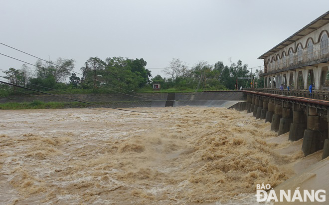 |
| The water level in Vu Gia River rises and overflows onto the An Trach Dam. Photo: HOANG HIEP |
The rain in Quang Binh and Quang Tri provinces could see between 80mm and 180mm fall, with up to more than 200mm possible in some places.
As much as 80mm-180mm of rain could fall in Thua Thien- Hue and Quang Nam Provinces, along with Da Nang, and even more than 250 mm in some places. Quang Ngai Province could receive 60-120mm of rain while over 150mm could fall at isolated places.
Rain activity is expected to declince gradually over the parts from Quang Binh to Quang Ngai, including Da Nang, from Wednesday nigh, October 26, but moderate rain continues in some places, the regional weather service has indicated.
Regional forecasters have also issued warnings of flash floods and landslides for mountainous areas in the parts from Quang Binh to Quang Ngai, including Da Nang as widespread and prolonged torrential rains are in forecast for these areas.
The Mid-Central Region Centre for Hydro-Meteorological Forecasting has stated that there is a significant risk of potential flooding from rivers in the parts from Quang Binh to Quang Nam, including Da Nang, from Tuesday until Thursday, October 27, as heavy rain is lashing these areas.
Regional forecasters indicate that river levels in the warning areas are expected to reach from 3-5m at upstream areas and from 1.5-3.5 m at downstream areas. The water level on rivers from Quang Binh to Quang Nam, including Da Nang, is likely to hit its peak to to reach at alarm levels 1 to 2 while that on some rivers could reach alarm above level 2. Especially, river levels on Kien Giang River in Quang Binh Province, and Bo River in Thua Thien- Hue Province could reach alarm levels 2 to 3.
Vu Gia and rivers in Da Nang are also impacted as river levels are expected to reach alarm level 2 or above, and level 1 and above, respectively.
Forecasters have also issued warnings of flash floods and landslides for mountainous areas, and flooding alerts are in place in low-lying and riverside areas and urban areas in parts from Quang Binh to Quang Nam, including Da Nang.
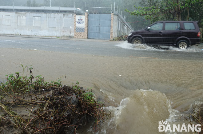 |
| 59.6mm of rain fell in the Da Stream Area located in Son Tra District between 4:00am and 70:00 am on Tuesday, October 25, sending a large amount of water from the mountain to flood Le Van Luong Street. Photo: HOANG HIEP |
The Da Nang Steering Committee for Natural Disaster Prevention, Search and Rescue and Civil Defence is urging authorities at local level and relevant units to take appropriate precautionary measures to cope with floods, flash floods, landslides brought by heavy downpours. The focus should be attached to desilting canals and facilitating the recharge of ground water besides avert damage due to floods.
All necessary measures are needed to move people living in low-lying areas, along rivers and streams and areas at high risk of flash floods and landslides to safe places. High priority should be given to evacuating people from riverside properties along Yen, Tuy Loan, and Cu De rivers in communes of Hoa Tien, Hoa Khuong, Hoa Bac, Hoa Lien, Hoa Phu, Hoa Phong, and Hoa Son and moutainous areas in Hoa Vang District, Son Tra Peninsula and other high risk areas for flash floods and landslides in line with municipal government-approved plan in an effort to protect the safety of local people during the bad weather.
Heed must be paid to keeping a close watch on severe weather development, and keep local residents timely informed about severe weather conditions in order to help them protect their property from heavy rains and flooding. Special attention must be given to making the resources available in order to drain rainwater from agricultural fields, low-lying areas, urban areas, most densely populated areas, industrial zones and other areas most at-risk of flooding in an effort to reduce costly damage to crops and property.
Importance is attached to banning people from travelling or fishing on rivers, low-lying areas, flooded areas, underground passages, flooded bridges, forests, mountains and landslide prone areas. Authorities and residents in flood-prone areas are asked to prepare for floods and possible isolation by stocking up on essential items including medication, food, and drinks.
The Da Nang Border Guard Command is asked to work with Da Nang Coastal Information Station to keep a close watch on severe weather development, and keep owners of vessels operating at sea timely informed about severe weather conditions in order to help them take the initiative to avoid dangerous areas or seek safe shelters during the bad weather. Special attention must be given to making the resources available in order to organize timely rescue of any person in distress at sea, as well as provide timely support for those who need it during severe weather.
Authorities at local level are closely monitoring severe weather development to take mitigation measures in response to severe weather events.
Reporting by HOANG HIEP – Translating by H.L