Instensifying Nalgae brings high tide threat to the Thua Thien Hue - Quang Ngai coast
In its latest bulletin, Viet Nam’s National Center for Hydro-meteorological Forecasting (NCHMF) on Sunday said that the center of Severe Tropical Storm Nalgae was located near latitude 16.3 North, longitude 118.2 East at 1:00pm, sat over the Eastern part of North East Sea, packaging maximum sustained winds reaching level 10, and the gusts as high as level 12.
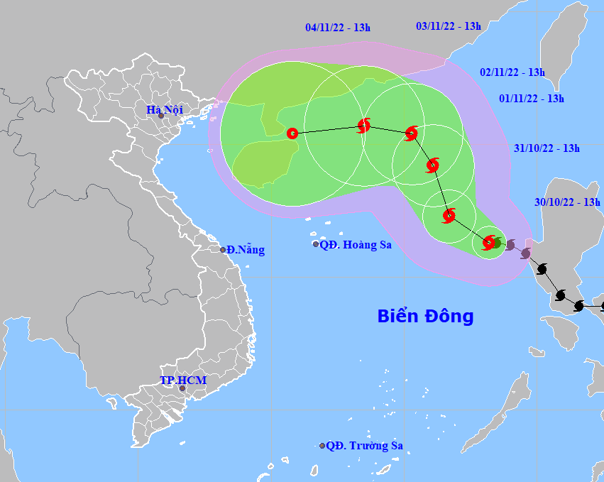 |
| Expected track of Severe Tropical Storm Nalgae. (Source: NCHMF). |
Nalgae is forecast to intensify over the next 24 hours as it cuts across the East Sea towards west- northwest at 10-15km per hour.
Forecast models indicate at 1:00pm on Monday, October 31, the storm will be centred near latitude 17.3 North, longitude 116.7 East, about 560km east of the Hoang Sa Islands, with the maximum sustained winds reaching levels at 10 to 11, and the gusts of level 13.
Nalgae is expected to take northerly track afterwards as it continues to move across the East Sea at 10km per hour.
The storm is predicted to strengthen into a typhoon by Monday night with a sustained maximum wind speed of 120km per hour, before easing back into a severe tropical storm on Tuesday.
At 1:00pm on Tuesday, November 1, the storm's center will be positioned near latitude 19.2 North, longitude 116.1 East, about 580km Northeast of the Hoang Sa Islands, packaging maximum sustained winds reaching levels at 11 to 12, and the gusts as high as level 14.
A warning for strong winds of levels at 7 to 8, sometimes levels at 8 to 9, and rough sea with waves as high as 6m-8m is issued to the Northern part of the East Sea (including the waters of the Hoang Sa Islands) during the daytime and night hours on Monday, October 31. The storm will have maximum sustained winds reaching levels at 10 to 12 near its center with gusts of levels at 13 to 14 while an alert for rough sea with waves as high 9m -11m is in place for this area.
The Gulf of Tonkin will see high winds of level 6, sometimes level 7, with gusts of level 8 under the influence of the storm. Strong winds of level 6, sometimes level 7, gustiness of levels at 8 to 9, with rough sea and waves as high as 3m-5m are in forecast for the open waters off the Quang Tri - Ninh Thuan Coast.
Residents are being warned to stay away from coastal areas as the storm is predicted to bring a tidal surge along the Thua Thien Hue - Quang Ngai Coast, including Da Nang. The warning is in place from Sunday until Wednesday, November 2. Coastal areas in the parts from Thua Thien- Hue to Quang Ngai, including Da Nang, have been put on alert as high tides of up to 2m-4m, sometimes over 4m with rough sea are expected to occur on Sunday.
NCHMF also issues a High Tide Warning to the open waters off the coast of the parts from Thua Thien- Hue to Quang Ngai, including Da Nang, with high tides of 3m-5m high and rough sea expected to occur starting from Monday into Wednesday, November 2.
The combined effects of high waves and tides will increase the risk of coastal flooding and erosion along the Thua Thien Hue - Quang Ngai Coast.
Reporting by HOANG HIEP – Translating by H.L