New tropical depression expected to gain in strength as it heads East Sea
Meteorologists at Viet Nam’s National Centre for Hydro-Meteorological Forecasting (NCHMF) are eyeing a new tropical depression which has formed off the coast of Luzon Island, the Philippines.
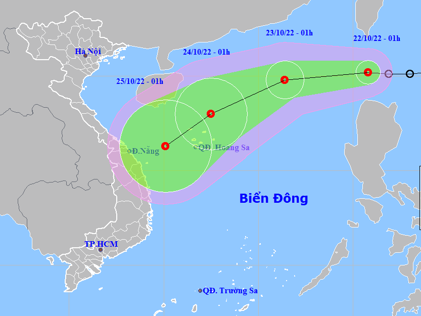 |
| The projected path and intensity of the newly-formed tropical depression. (Source:NCHMF) |
NCHMF said in a bulletin issued at 1:00am on Saturday, October 22, the depression was centred near latitude 20°2'N and longitude 120°8'E, about 160 km north of Luzon Island, the Philippines, moving westward at about 20 km per hour. The area near the depression’s center experienced maximum sustainable winds at level 6 (39-49 km per hour), and gustiness of up to level 8.
Significant intensification is forecast over the next 24 to 48 hours, the national weather service said. However, little change in strength is forecast over the next 48 to 72 hours as the depression moves generally west- southwestward at about 10-15 km per hour.
Warnings for northeasterly winds at level 5, and the gusts as high as levels 7 to 8, plus rough sea has been issued for the eastern part of the North East Sea.
During daytime and night hours on Sunday, October 23, North East Sea area (including the waters of the Hoang Sa Archipelago) will see high winds at levels 6 to 7, and gustiness of up to level 9, along with rough sea with waves as high as 3-5. NCHMF has issued a weather warning for strong winds and high waves to all vessels operating at these areas.
Here's the latest forecast track.
According to the 7:00 a.m. update from NCHMF, the depression's center was located near latitude 20°2'N and longitude 120°2'E, about 180 km north-northwest of Luzon Island, the Philippines while the system was tracking westward at 15-20 km per hour. The maximum sustainable winds at level 6 (39-49 km per hour) and gustiness of up to level 8 affected the area near the depression’s center.
At 7:00 a.m. on Sunday, October 23, the system will be centred near latitude 19°7'N and longitude 115°5'E, about 530 km north-northeast of the Hoang Sa Islands as it drifts westward about 15 -20 km per hour. The area near the depression’s center will see maximum sustainable wind at level 7, and gustiness of up to level 9.
The danger area around the tropical depression will be located near latitude 18°N -21°5'N and longitude 113°E. Warning for level 3 natural hazard risk is issued to the waters of North East Sea.
At 7:00 am on Monday, October 24, the system will be positioned near latitude 17°8'N and longitude 111°3'E, about 160 km north of the Hoang Sa Islands as it moves west-southwest at about 15-20 km per hour. The area near the depression’s center will experience maximum sustainable winds at level 7, and gustiness of up to level 9. The danger area around the tropical depression will be located at latitude 16°N -21°N and longitude 109°5'E- 114°E. Warning for level 3 natural hazard risk is issued to the waters of North East Sea.
From Tuesday, October 25, the tropical depression will have sustainable winds at level 6 and and gustiness of up to level 8 as it continues its track towards west- southwest at about 10-15 km per hour.
The national weather service issues flood warnings for rivers in the parts from Quang Binh to Thua Thien Hue from Saturday until Monday, October 24 as these rivers could face flood risk with floodwater expected to peak from 3 - 5m at their upstream areas and 1 - 3m at their downstream areas.
Water levels in rivers in the parts from from Quang Binh to Thua Thien Hue are likely to reach its peak to reach alarm levels 1 to 2. Especially, the water level in the Kien Giang River in Quang Binh Province is expected to reach alarm levels 2 to 3, posing threat of flooding to the affected area.
Forecasters have also issued warnings of flash floods and landslides for mountainous areas, and localized flooding alerts are in place in low-lying and riverside areas and urban areas over the parts from Quang Binh to Thua Thien- Hue. Warning for level 1 natural hazard risk is issued to these areas.
According to the latest weather forecast by the NCHMF, heavy rains are likely to continue over the parts from Quang Binh to Quang Ngai, including Da Nang, through Sunday, October 23.
The parts from Ha Tinh to Da Nang has experienced moderate to heavy rain with localised very heavy downpours over the past 24 hours. From 7:00pm on Friday into 7 a.m. on Saturday, October 22, 88.4mm of rain was dumped on Ky Thinh, Ha Tinh Province, 172.8mm of rain fell on Le Thuy, Quang Binh Province, 168.6mm of rain on Truong Thuy, Quang Binh Province, 137mm of rain on Vinh Kim, Quang Tri Province.
As per the national weather service, moderate to heavy rainfall with isolated very heavy falls are very likely over the parts from Quang Binh to Quang Ngai, including Da Nang, during daytime and night hours on Saturday. The rainfall activity will gradually decline from Sunday, October 23.
Forecasters urge all residents in the warning areas to continue monitoring the disturbance development and to always be prepared for severe weather conditions.
The Da Nang Steering Committee for Natural Disaster Prevention, Search and Rescue and Civil Defence is urging authorities at local level and relevant units to take appropriate precautionary measures to cope with floods, flash floods, landslides brought by heavy downpours. The focus should be paid to taking proactive response to the arrival of new tropical depression.
Reporting by HOANG HIEP – TRIEU TUNG - TTXVN – Translating by H.L