Slowly-moving Nalgae poses coastal erosion threat
According to the 4:00 am on Monday update from Viet Nam’s National Centre for Hydro-Meteorological Forecasting (NCHMF), the center of Severe Tropical Storm Nalgae was located about 590km east of the Hoang Sa (Paracel) Islands, packaging maximum sustained winds reaching level 10, and the gusts as high as level 12.
Under these conditions, the eastern part of the north and the middle of the East Sea, experienced strong winds reaching levels at 7 to 8 on Monday morning while the area near the storm’s center saw high winds of levels at 9 to 10, and gustiness of level 12, national forecasters said.
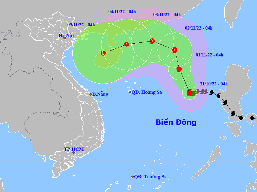 |
| The forecast track of Tropical Storm Nalgae. (Source: NCHMF). |
Significant intensification is forecast over the next 24 to 48 hours as the cyclone moves over the East Sea.
Forecast models indicate at 4:00 a.m. on Tuesday, November 1, the storm will be centred near latitude 18.3 degrees North, longitude 116.1 degrees East, about 530km northeast of the Hoang Sa Islands, with the maximum sustained winds reaching levels at 10 to 11, and the gusts of level 13.
Nalgae is expected to move slowly towards north- northwest at 10km per hour afterwards. At 4:00 a.m. on Wednesday, November 2, the storm’s center will be positioned near latitude 20 degrees North, longitude 115.7 degrees East, about 600km east of the Hoang Sa Islands, with sustained winds reaching levels at 10 to 11, and gustiness of level 13.
A warning for strong winds reaching levels at 7 to 8, sometimes levels at 8 to 9, and rough sea with waves as high as 6m-8m under the influence of the storm is issued to the eastern part of the north and the middle of the East Sea. The storm will have maximum sustained winds reaching levels at 10 to 12 near its center with gusts of level 13 while an alert for rough sea with waves as high 9m -11m is in place for these areas.
The western part of the north and the middle of the East Sea (including the waters of the Hoang Islands) will see strong winds reaching levels at 6 to 7 with the gusts as high as levels 8 to 9 and rough sea.
Strong winds of level 6, sometimes level 7, gustiness of levels at 8 to 9, with rough sea and waves as high as 3m-5m are in forecast for the open waters off the Quang Tri - Ninh Thuan Coast on Monday and Tuesday.
National forecasters also issue a warning for strong winds and big waves to all vessels operating at the warning areas.
The combined effects of high waves and tides will increase the risk of coastal flooding and erosion along the Quang Tri - Ninh Thuan Coast.
Reporting by HOANG HIEP – Translating by H.L