Storm Nalgae heads to East Sea, expected to bring high winds and waves to coastal and open waters of Central Viet Nam
Meteorologists at Viet Nam’s National Centre for Hydro-Meteorological Forecasting are keeping an eye on tropical storm Nalgae which has cut through the main Luzon Island, the Philippines, and is heading to the East Sea.
The tropical storm, officially named Nalgae by the Japan Meteorological Agency, the tropical authority for the basin, formed on Thursday. This storm is known as Paeng in the Philippines. Nalgae has killed at least 72 people and injured 33 in the Philippines after churning across the Philippines Sea, unleashing deadly flooding and landslides in this country on Thursday night and Friday.
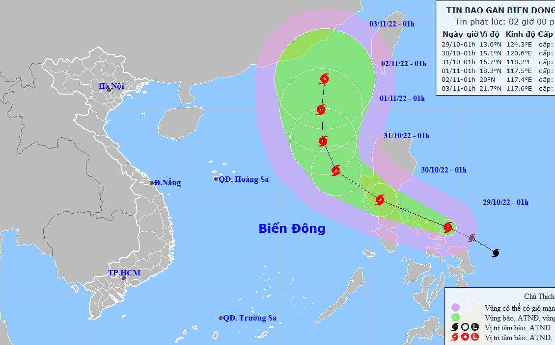 |
| Storm Nalgae’s expected path (Source: Viet Nam’s National Centre for Hydro-Meteorological Forecasting). |
Forecast models indicate at 1:00am on Saturday, October 29, the storm’s center was spotted at near latitude 13°6'N and longitude 124°3'E, sat over the open waters off the east coast of the central Philippines. The storm had maximum sustained winds of levels 9 to 10 (75-102km per hour) near the center and gustiness of up to level 12.
According to the Mid-central Centre for Hydro-Meteorological Forecasting, the open waters off the Quang Tri - Quang Ngai coast, including Da Nang, on Saturday morning saw strong northeasterly winds of levels 4 to 5, sometimes increased to level 6 in the southern part, and gusts exceeding level 6, as well as experienced rough sea.
Over the next 24 hours, the storm will move west-northwestward at 15-20km per hour. At 1:00 a.m. on Sunday, October 30, the storm will be centred near latitude 15°1'N and longitude 120°6'E, with the maximum sustained winds reaching levels 9 to 10, and the gusts as high as level 12.
The storm will move into the East Sea as it continues its tracks towards west-northwest at 15-20km per hour, and it is expected to get stronger. At 1:00am on Monday, October 31, the storm’s centre will be positioned near latitude 16°7'N and longitude 118°2'E, packaging maximum sustained winds at level 10, and gustiness of level 12.
Due to the influence of the storm, the eastern part of North East Sea and the middle of the East Sea will see gradually increasing strong winds at levels 7 to 8. The storm will have maximum sustained winds at levels 9 to 10 near its center with gustiness of level 12 while rough sea with waves as high as 5-7m will affect this area. In addition, the North East Sea (including the waters of the Hoang Sa (Paracel) Islands) will experience strong northeasterly winds reaching levels 6 to 7.
Under these condition, during the daytime and night hours on Saturday, October 29, the open waters off the Quang Tri - Quang Ngai coast will see strong northeasterly winds reaching level 6, and gustiness of levels 7 to 8, as well as rough sea with waves as high as 2-4m.
During the daytime and night hours on Sunday, October 30, the open waters off the Quang Tri - Quang Ngai coast will experience strong northeasterly winds reaching level 6, sometimes increase to level 7, with gustiness of levels 8 to 9, rough sea with waves as high as 2-4m.
National forecasters issue a warning for strong winds and big waves to all vessels operating at sea. In addition, the severe weather conditions will bring fears of coastal erosion to the warning areas.
Reporting by HOANG HIEP – Translating by H.L