Storm Nesat forecast to weaken to tropical depression
Viet Nam’s National Centre for Hydro-Meteorological Forecasting (NCHMF) continues to monitor Storm Nesat which is expected to gradually weaken in the coming time.
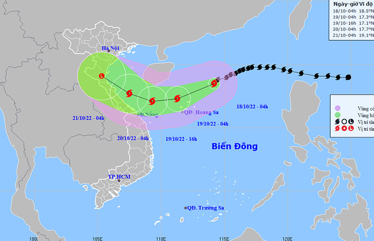 |
| The map shows the expected path of storm Nesat. Photo: NCHMF |
In its latest bulletin, the National Weather Service said that at 4:00am on Tuesday, October 18, the storm's centre was spotted near latitude 18°5'N and longitude 114°2'E, about 350km northeast of the Hoang Sa Archipelago. The maximum sustained winds reaching levels 12 to 13 (118-149km per hour), and the gusts as high as level 15 will affect the area near the storm’s center. The storm was moving in the west-southwest direction at about 15km per hour.
Over the next 48 hours to 72 hours, Nesat will likely weaken back to a depression and then degenerate into a remnant low as it tracks the west- northwestward at 10-15km per hour, according to the latest forecast track.
Alerts for thunderstorms, strong winds at levels 9 to 10, and even levels at 11 to 12 with gusts of level 14 with rough seas are issued for the northern part of the East Sea (including the waters of the Hoang Sa Islands). Heavy showers and thunderstorms are expected to develop in northwest of the middle of the East Sea, and this area could see gradually increasing strong winds at levels 6 to 7, and gustiness of level with rough sea.
The Gulf of Tonkin and the offshore area stretching from Quang Tri to Quang Nam, including Da Nang, will experience high winds at levels 6 to 7, and the gusts as high as level 8 to 9, with rough sea.
The Northern part of the East Sea will experience rough seas and waves as high as 6m to 8m while the area near the storm’s center will experience rough seas and waves as high as 8m to 10 m. The middle of the East Sea will experience rough seas and waves as high as 4m to 6 m while the Gulf of Tonkin and the offshore area stretching from Quang Tri to Quang Nam experience rough seas and waves as high as 3m to 5m.
Warning for level 3 natural hazard risk has been also issued for these areas.
Alerts for strong winds at levels 6 to 7 with gusts of level 9 with rough seas and waves as high as 3m to 5m are issued for Wednesday, October 19 in the Gulf of Tonkin, and the offshore area stretching from Quang Tri to Quang Nam, inluding Da Nang. The Northern part of the East Sea area (including the waters of the Paracel Islands) will see high winds of levels at 6 to 7 while the area near the storm’s centre will have sustainable winds at level 9 to 10, and the gusts as high as level 11, with rough seas and waves as high as 5m to 7 m while the area near the center of the storm will experience rough seas and waves as high as 7m to 9 m. Warning for level 3 natural hazard risk has been issued to sea.
An advisory for strong winds and high waves has been issued for all vessels operating at sea.
Reporting by Baotintuc- Translating by H.L