Strengthening LPA in East Sea expected to become tropical depression
A tropical depression could form over the next 24 hours in the East Sea, according to the Mid-Central Region Centre for Hydro-meteorological Forecasting.
Forecasters are watching a low pressure area (LPA) in the middle of the East Sea and the system is getting stronger as it moves over the East Sea. The system is expected to intensify and strengthen into a tropical depression, according to regional forecasters.
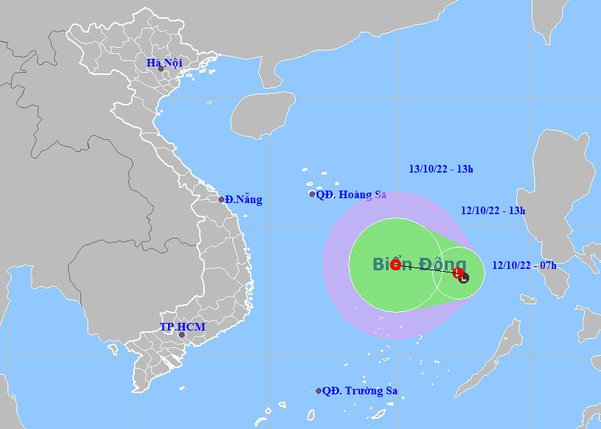 |
| The expected track of LPA which is likely to strengthen into a tropical depression (Source: Viet Nam’s National Centre for Hydro-Meteorological Forecasting) |
The system has a high chance of developing into a tropical depression as it moves westward over the East Sea.
Under these conditions, the offshore area stretching from Da Nang to Quang Ngai will see high winds at level 6 to 7, and the gusts reaching level 7, and experience rough seas with waves as high as 2-4m from Wednesday into Thursday, October 13.
Thursday into Friday, October 14, the offshore area stretching from Quang Binh to Thua Thien Hue could see strong winds at level 5, and the gusts as high as level 6, and experience rough seas with waves as high as 2-4m while the offshore area stretching from Da Nang to Quang Ngai, including the Hoang Sa Archipelago, will see high winds at levels 6 to 7, and gustiness of level 8 with rough seas and waves as high as 3-5m.
Forecast models indicate at 1:00pm on Wednesday, October 12, the LPA was spotted at near latitude 12°2' N - 14°2' N and longitude 116°3' E -118°3' E.
Over the next 24 hours, the system will move westward in the East Sea at 10km per hour, and it will continue to gain strength and is likely to develop into a tropical depression.
At 1:00pm on Thursday, October 13, the potential depression’s centre will be positioned near latitude13°5'N and longitude 114°9'E, about 220 km northeast of Song Tu Tay Island, packaging maximum sustained winds reaching levels at 6 to 7, and the gusts as high as level 9.
A strong wind warning is issued in the next 24 hours to all vessels operating in the potentially dangerous area which is located at latitude 11°N - 15°N and longitude 113°5' E - 118.5' E as the warning area will experience strong winds at level 6 or higher, and gustiness of level 8 or higher.
Due to the influence of the LPA which is likely to become a tropical depression, showers and strong thunderstorms will be possible in the middle of the East Sea (including the northern part of the Truong Sa Islands) while the warning area will see high winds at levels 6 to 7, and the gusts as high as level 9, with rough seas and waves as high as 3-5m.
Reporting by HOANG HIEP – Translating by H.L