Tropical depression forms, expected to strengthen into a storm
National weather forecasters are tracking a new tropical depression intensified from the low pressure area (LPA) in the middle of the East Sea.
The LPA became a tropical depression in the East Sea on Thursday morning, and it is expected to strengthen into a storm, according to Viet Nam’s National Center for Hydro-meteorological Forecasting (NCHMF).
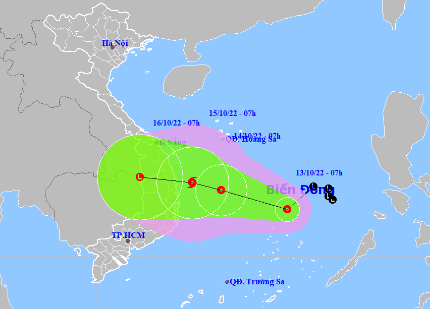 |
| The forecast track of the newly-formed tropical depression over the East Sea. (Source: NCHMF). |
Forecast models indicate at 7:00 am on Thursday, the centre of the depression was already postioned at latitude 12°5'N and longitude 115°1'E, about 180km north of Song Tu Tay Island, with the maximum sustained winds reaching level 6, and the gusts as high as level 8.
Over the next 24 hours, the depression will move westward in the East Sea at about 10km per hour.
At 7:00am on Friday, October 14, the depression will be centred at latitude 13°5'N and longitude 114°6'E, packaging maximum sustained winds reaching level 7, and gustiness of level 9. The system will move in a west-northwest direction in the East Sea at 15km per hour.
The depression will have sustained winds reaching level 8, and the gusts as high as level 10, and is expected to strengthen into a tropical storm at 7:00 a.m. on Saturday, October 15, meteorologists said.
The combined effects of the depression and the northeast monsoon will bring strong showers and thunderstorms to the middle of the East Sea (including the northern part of the Truong Sa (Spratly) Islands) while the warning area will see high winds at levels 6 to 7, and the gusts as high as level 9, with rough seas and waves as high as 3m to 5m.
The Northern part of the East Sea (including the waters of the Hoang Sa (Paracel) Islands) could experience gradually increasing northeast winds at levels 6 to 7, and the gusts as high as levels 8 to 9 with rough seas and waves as high as 4m to 6m.
The offshore area stretching from Quang Ngai to Binh Thuan will see high winds at level 5, and gustiness of levels at 7 to 8, and experience rough seas with waves as high as 2m to 4m.
The national weather service issues storm surge watches and warnings for coastal areas from Thua Thien -Hue to Phu Yen, including Da Nang, with 0.2m–0.4m surge alert. National forecasters also issue flooding warnings for low-lying areas due to storm surge and high waves. In addition, the severe weather conditions will bring fears of coastal erosion for the warning areas.
According to the latest weather forecast by the NCHMF, heavy rains are likely to continue over the parts from Quang Binh to Khanh Hoa, including Da Nang, and Central Highlands from late Thursday afternoon till Sunday, October 16. The total rainfall amount will be 200-500mm in common in these areas while more than 600mm of rain could fall in some places.
Reporting by HOANG HIEP – Translating by H.L