Tropical depression in East Sea strengthens into storm SONCA, threating parts from Da Nang to Quang Ngai
The tropical depression in the middle of the East Sea was intensified into a tropical storm on Friday noon and it was named SONCA, according to Viet Nam’s National Center for Hydro-meteorological Forecasting (NCHMF).
SONCA is the fifth storm to enter the East Sea so far this year.
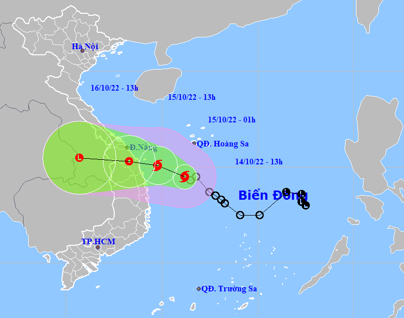 |
| The expected track of storm SONCA (Source: NCHMF) |
Forecast models indicate at 3:00pm on Friday, the storm’s center was spotted near latitude 14°4'N and longitude 110°8'E, about 325km southeast of Da Nang, about 285km southeast of Quang Nam, about 235km southeast of Quang Ngai, packaging sustained winds reaching level 8 (62-74 kilometres per hour), and the gusts as high as level 10. The storm is moving in the west- northwest direction at about 15 kilometres per hour.
At 1:00 am on Saturday, October 15, the storm will be centred near latitude 15°1'N and longitude 109°8'E, sit over the waters off the coast of the parts from Thua Thien- Hue to Quang Ngai, about 90km east of the Quang Ngai - Da Nang coast, with the maximum sustained winds reaching level 8, and gustiness of level 10.
The storm will continue its track west-northwest at about 10-15km per hour, and it is projected to weaken into a tropical depression. At 1:00pm on Saturday, October 15, the storm’s centre will be positioned near latitude 15°3'N and longitude 108°3'E, sit over the parts from Da Nang to Quang Ngai, packaging sustained winds reaching level 6, and the gusts as high as level 8.
NCHMF issues warnings for rain, thunderstorms, and strong winds and rough sea in the northwest part of the midde of the East Sea and the offshore area stretching from Quang Tri to Phu Yen (including Con Co and Ly Son islands) as these areas could see strong winds at levels 7 to 8, and gustiness of level 10.
The Northern part of the East Sea (including the waters of Hoang Sa islands) could experience gusty northeast winds at levels 6 to 7, and the gusts as high as levels at 8 to 9 and rough seas. Storm SONCA with wind gusts level 10 is expected to drop heavy rain in the parts from Thua Thien - Hue to Quang Ngai, meteorologists at NCHMF said.
From Friday evening, October 14, the coastal areas in the parts from Thua Thien - Hue to Binh Dinh, including Da Nang, will see high winds at levels 6 to 7, and gustiness of levels 8 to 9.
Heavy rains are lashing Central Viet Nam and Central Highlands. From Thursday through Sunday, October 16, the total rainfall amount will be 200mm to 500mm in common in the parts from Quang Binh to Khanh Hoa, including Da Nang, the Northern part of Central Highlands while more than 600mm of rain could fall in some places. In particular, as much as 400mm-600mm of rain could fall over the parts from Quang Tri to Quang Ngai, including Da Nang, and even more than 800mm at isolated locations.
The national weather service issues storm surge watches and warnings for coastal areas from Thua Thien -Hue to Binh Dinh, including Da Nang, with 0.2m–0.4m surge alert. National forecasters also issue flooding warnings for low-lying areas due to storm surge and high waves. In addition, the severe weather conditions will bring fears of coastal erosion for the warning areas. The coastal areas stretching from Quang Ngai to Binh Thuan could experience rough sea with waves as high as 2-4m.
National forecasters indicate heavy rainfall of 400 mm to 500mm in Quang Tri, Thua Thien Hue, Da Nang and Quang Nam, and even in excess of 700mm at isolated places. Quang Ngai Province could receive 300-400mm of rain while over 500mm of rain could fall at some places.
The national weather service issues flood warnings for rivers in the parts from Quang Binh to Khanh Hoa, including Da Nang, Kon Tum, Gia Lai and Dak Lak from Friday until Monday, October 17 as these rivers could face flood risk with floodwater expected to peak from 4 - 10m at their upstream areas and 1.5 - 5m at their downstream areas.
The water level in rivers in the parts from Quang Tri to Phu Yen, Kon Tum and Gia Lai is likely to reach its peak to reach alarm levels 2 to 3 and above while that in rivers in Quang Binh, Khanh Hoa and Dak Lak are expected to reach alarm levels 2 to 3, while that on some rivers will reach alarm level 2, posing threat of large-cale floods and widespread flooding to the affected areas.
Forecasters have also issued warnings of flash floods and landslides for mountainous areas, and localized flooding alerts are in place in low-lying and riverside areas along with urban areas in parts from Quang Binh to Khanh Hoa, Kon Tum, Gia Lai and Dak Lak.
Reporting by HOANG HIEP - TTXVN – Translating by H.L