Tropical Storm Nesat forms, heading towards Thua Thien- Hue to Ha Tinh
The tropical depression which has strengthened to tropical storm Nesat in Northern Luzon Island, Philippines, and the storm moved into the East Sea on Sunday afternoon, October 16, Viet Nam’s National Centre for Hydro-Meteorological Forecasting (NCHMF) said.
It is the sixth named storm that has entered the East Sea so far this year.
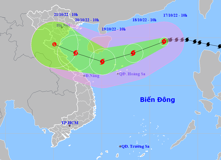 |
| The expected track of Nesat (Source: NCHMF) |
Forecast models indicate at 4:00am on Monday, October 17, the storm’s centre was already spotted at near latitude 19°8'N and longitude 117°2'E, about 720km northeast of the Hoang Sa (Paracel) Archipelago. The maximum sustained winds reaching levels 11 to 12 (103-133km per hour), and the gusts as high as level 14 affected areas near the storm’s center. The tropical storm was moving to the west at about 20km per hour.
At 4:00 pm on Monday, October 17, Nesat will be located about 630km northeast of the Hoang Sa Archipelago, with the maximum sustained winds at level 12, and the gusts as high as level 15. Environmental conditions are forecast to be conducive for development and the storm is expected to grow even stronger.
The national weather forecasters also said the cold air is pouring southward into Central Viet Nam, and it is expected to affect Da Nang on Monday noon or afternoon. By the coastal areas they will see high winds at level 4 to 5, and farther inland you could find northeast winds at level 3.
Under these conditions, early Monday morning, October 17, the Gulf of Tonkin and the Northern part of the East Sea (including the waters of the Hoang Sa Archipelago) saw gradually increasing northeasterly winds at levels 6 to 7, and gustiness of level 9, as well as experienced rough seas with waves as high as 2-3m. From Monday, the open waters off the Da Nang coast could experience high winds at level 6, and gustiness of levels at 7 to 8, rough seas with waves as high as 2-3m. A severe thunderstorm warning is in effect for this area as thunderstorms can cause dangerous lightning, tornadoes and strong winds.
Over next 48 to 72 hours, the storm will move generally westward at 10-15km per hour, packing maximum sustained winds at levels 8 to 9, and and gustiness of level 11.
Over the next 72 to 96 hours, the storm is forecast to gradually weaken back into a tropical depression as it tracks west-northwest at about 10km per hour, packaging sustained winds reaching level 5, and the gusts as high as level 8.
Additional weakening is expected over next 96 to 120 hours while tropical depression continues its track towards the west-northwest at about 10km per hour.
In its latest bulletin, the national weather service said at 10:00 am on Monday, October 17, the storm’s centre was already located about 600km northeast of the Hoang Sa Islands, with sustained winds reaching levels 11 to 12, and the gusts as high as level 14.
The storm is expected to pick up strength as it tracks the west- southwestward at 15 km per hour. At 10:00 am on Tuesday, October 18, Nesat will be positioned about 180km northeast of the Hoang Sa Islands, with maximum sustained winds at levels 12 to 13, and gustiness of level 15.
Nesat is forecast to weaken before reaching the coast of mainland in the parts from Ha Tinh to Thua Thien- Hue. At 10:00am on Wednesday, October 19, the storm will be located about 380km southeast of the mainland from Ha Tinh to Thua Thien Hue, with sustained winds at levels 9 to 10, and the gusts as high as level 12.
The Da Nang Steering Committee for Natural Disaster Prevention, Search and Rescue and Civil Defence is urging authorities at local level and relevant units to take mitigation measures in response to the arrival of storm Nesat and the northeast monsoon.
Focus must be on keeping a close watch on severe weather development, and keep local residents timely informed about extreme weather conditions in a bid to keep them safe and protect their properties. In addition, the heed must be paid on helping local residents get ready for such weather conditions in an attempt to reduce the risk of possible damages. Special attention must be given to keeping owners of vessels operating at sea timely informed about extreme weather conditions in order to help them take the initiative to avoid dangerous areas or seek safe shelters during the bad weather. Importance must be attatched to making the resources available in order to organize timely rescue of any person in distress at sea and provide timely support for those who need it during severe weather.
The authorities at local level must take resilience measures to help save lives and reduce the damage to individual houses, public infrastructure and crops.
All necessary measures are needed to move people living in low-lying areas, along rivers and streams and areas at high risk of flash floods and landslides to safe places. High priority should be given to evacuating people from riverside properties along Yen, Tuy Loan, and Cu De rivers in communes of Hoa Tien, Hoa Khuong, Hoa Bac, Hoa Lien, Hoa Phu, Hoa Phong, and Hoa Son and moutainous areas in Hoa Vang District, Son Tra Peninsula and other high risk areas for flash floods and landslides in line with municipal government-approved plan in an effort to protect the safety of local people during bad weather.
Reporting by HOANG HIEP – Baotintuc – translating by H.L