Hot weather expected to give way to milder conditions next week in Da Nang, tropical depression moves into East Sea
Excessively hot weather will give way to milder conditions in Da Nang next Monday, May 8, the Mid-Central Region Centre for Hydro-meteorological Forecasting says.
Da Nang is under heat advisory as the scorching temperatures are currently baking the city.
The city will sizzle on Saturday as the mercury may rise above 39 degrees Celsius at isolated locations, with 37 to 39 degrees Celsius expected across the city. Lowest humidity is likely to record at 45-55 per cent.
Temperatures are forecast to stay high in Da Nang into Sunday, May 7 while milder conditions are expected in the city from Monday, May 8.
The central region weather service also issues a severe thunderstorm warning for Da Nang, especially its mountainous areas, during noon and afternoon hours in the context of such hot weather.
The Da Nang Steering Committee for Natural Disaster Prevention and Control is urging authorities at local level and relevant agencies to take proactive and necessary mitigation measures in response to thunderstorms that can produce tornadoes, lightning, hail and strong winds, greatly affecting the production and social life in order to minimize losses owing to thunderstorms.
At the same time, the focus is on encouraging local residents to take the necessary precautions to avoid exposure to the extreme conditions, as well as learn the risk factors and symptoms of heat-related illness to protect themselves and their family members.
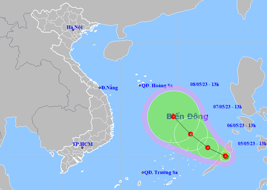
Regional weather forecasters are tracking a new tropical depression intensified from the low pressure area (LPA) in the central Philippine sea.
The LPA became a tropical depression in the central Philippine sea on Friday morning.
 |
| The expected track of the tropical depression (Source: The National Centre for Hydro-Meteorological Forecasting) |
Forecast models indicate at 10:00 am on Friday, the centre of the depression sat over Philippine Islands, east coast of Palawan, packaging sustained winds reaching level 6, and the gusts as high as level 8.
The tropical depression with the maximum sustained winds reaching level 6, and the gusts as high as level 8, moved into the East Sea at 10:00 am today (May 6) while it was postioned near latitude 10°7'N and longitude 117°8'E. The regional weather service has issued Natural Disaster Alert at level 3 for the middle and southern parts of the East Sea.
However, little change in strength is forecast over the next 24 -48 hours as it moves toward the west-northwest over the East Sea at about 10kmph.
Under these conditions, the middle and southern parts of the East Sea will experience gradually increasing strong winds at level 6, and the gusts as high as level 8, with rough seas and waves as high as 2m to 3m.
The danger area around the tropical depression is expected to be located at latitude 9°N - 12°N and longitude 116°5'E. Warning for strong winds and big waves has been issued for all vessels operating in the danger area.
The Da Nang Steering Committee for Natural Disaster Prevention and Control is urging authorities at local level and relevant agencies to take proactive and necessary mitigation measures in response to the development of the newly-formed tropical depression.
The authorities at local level must keep a close watch on severe weather development, and keep owners of vessels operating at sea timely informed about severe weather conditions in order to help them take the initiative to avoid dangerous areas or seek safe shelters during the bad weather. The focus must be on making the resources available in order to organize timely rescue of any person in distress at sea, and provide timely support for those who need it during severe weather.
In addition, the heed must be paid on assisting local residents to prepare for severe weather in an attempt to keep them safe and protect their properties.
Reporting by HOANG HIEP – translating by H.L