Talim expected to strengthen before weakening back to tropical depression
Hours after becoming the first named system of the 2023 East Sea Season, Tropical Storm Talim is expected to fizzle back to a tropical depression, and then further weaken in the coming days, according to Viet Nam’s National Centre for Hydro-Meteorological Forecasting (NCHMF).
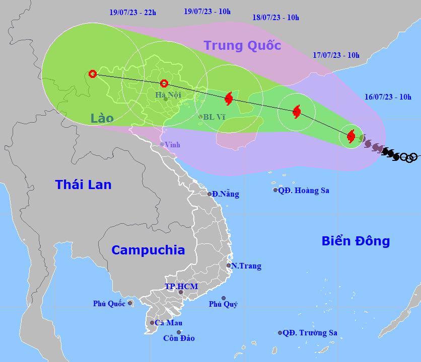 |
| The projected Talim path and map (Source: NCHMF) |
Forecast models indicate that at 10:00am on July 16, Talim’s centre was located near latitude 19.1 North, longitude 115.7 East, about 610km southeast of China’s Leizhou Peninsula, packaging maximum sustained winds reaching levels at 9 to 10, and the gusts as high as level 13.
Over the next 24 hours, Talim is forecast to strengthen into a typhoon as it continues to move west-northwest at 10-15 kilometres per hour across the northern East Sea.
At 10:00 am on July 17, the typhoon will be centred near latitude 20.4 North, longitude 112.8 East, about 280km east of China’s Leizhou Peninsula, with maximum sustained winds reaching levels at 11 to 12, and the gusts as high as level 15.
Over the next 48 hours, the storm will continue its west-northwestward track at 15 kilometres per hour. On the forecast track, Talim is expected to make landfall over the northern Leizhou Peninsula in far southwestern Guangdong Province, China, early July 18.
At 10:00 am on July 18, the storm's centre will be positioned near latitude 21.1 North, longitude 109.2 East. Under the influence of Talim, the northern Gulf of Tonkin could see strong winds at level 12 and gusts of level 15.
The system is expected to weaken back to tropical storm strength as it skirts along the south coast of Guangxi Province and into far northern Viet Nam on July 18. Talim will continue to track west-northwestward at 15 kilometres per hour while gradually weakening back into a tropical depression after making landfall over the northern Leizhou Peninsula early July 18.
At 10:00 a.m. on July 19, the depression will be centred near latitude 21.9 North, longitude 105.8 East. Northeast region of Viet Nam will experience high winds at level 5, and gustiness of levels at 7 to 8.
The system is expected to dissipate near the border between northern Viet Nam and Yunnan Province on July 19. Some uncertainty remains in the track and intensity forecast, and significant changes could occur in the coming days.
Alerts for strong winds at levels 7 to 8 are issued for the northern East Sea while the area near the storm’s center will experience high winds at levels 9 to 10, then increase to levels at 11 to 12, and gustiness of level 15 with rough seas and waves as high as 5m to 7m.
Reporting by HOANG HIEP – Translating by H.L