Tropical storm Talim expected to dissipate by early Wednesday
Talim became the first typhoon to make landfall in China this year on Monday night, prompting authorities to issue flood warnings, cancel flights and trains, and order people to stay at home.
Talim, the fourth typhoon of the year, made landfall at 10:20 p.m. in Zhanjiang city of Guangdong province, with winds near its centre clocked at a top speed of 136.8 kph (85 mph), according to Guangdong weather bureau.
The storm’s center was located near latitude 21.4 North, longitude 109.3 East, lied to northeast of the Gulf of Tonkin, about 140km southeast of Mong Cai, Viet Nam’s National Center for Hydro-meteorological Forecasting (NCHMF) said in a bulletin at 4:00am on Tuesday, July 18. Talim had maximum sustained winds at levels 10 to 11 (89-117km per hour), near the center, and gusts of level 14.
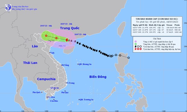 |
| The projected Talim path and map (Source: NCHMF) |
At 4:00pm on Tuesday, Talim is expected to gradually weaken as it moves west northwestward at about 20km per hour. The storm’s centre will be positioned near latitude 21.8 North, longitude 107.1 East, sit over Northeast Viet Nam. The storm will have maximum sustained winds reaching level 7 near the center, and the gusts as high as level 9.
At 4:00am Wednesday, July 19, the storm is expected to continue its west- northwest track at 20-25km per hour, and it is projected to continue a gradual weakening trend. The system is forecast to dissipate as it moves father land.
Under the influence of tropical storm Talim, the coastal areas from Quang Ninh and Hai Phong could see strong winds at levels 6 to 7 while the area near the storm’s center will experience high winds at levels 8 to 9, and gustiness of level 11. Meanwhile, Lang Son, Bac Giang and Thai Binh provinces could see gusty winds at level 8.
Waves as high as 3-5m, 2-4m and 2-3m are expected to assail Northern East Sea, the Gulf of Tonkin, and the coastal areas from Quang Ninh to Thai Binh, respectively.
The national weather service issues storm surge watches and warnings for the coastal areas from Quang Ninh to Hai Phong with 0.3 - 0.5m surge alert. National forecasters also issue flooding warnings for low-lying areas and estuaries due to storm surge and high waves.
The storm is expected to bring heavy rainfall to Northern Viet Nam, as well as some relief from relentless heat wave on a 10-day stretch, with flash flooding and landslides possible across the region, especially Quang Ninh, Lang Son, Cao Bang, Ha Giang, Lao Cai and Yen Bai, from Tuesday into Wednesday, 19.
During the said period, heavy to extremely heavy rainfall is likely over Northeast Viet Nam and Viet Bac with the total rainfall amount expected to reach 200mm to 300mm in common across these areas, and even over 350mm possible in some places. Moderate to heavy rainfall with isolated very heavy falls are in forecast for Thanh Hoa and Nghe An. Rainfall totals are expected to range from 70 mm to 120mm.
Reporting by TTXVN-Vietnam+ - Translating by H.L