Tropical Storm Talim to bring heavy rain to Northern Viet Nam
As Tropical Storm Talim continues its journey across the northern East Sea, it is expected to weaken and dissipate over Wednesday, July 19, Viet Nam’s National Centre for Hydro-Meteorological Forecasting (NCHMF) has said.
 |
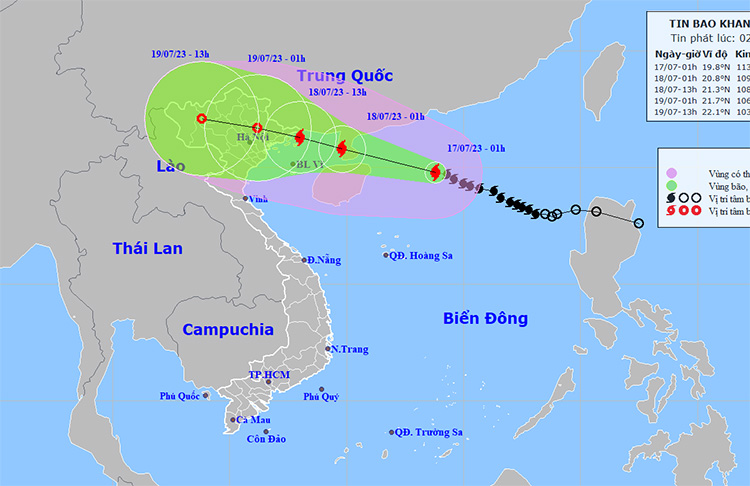
| The path of tropical storm Talim issued by NCHMF at 2: 00am on Monday, July 17. Photo: khottietvietnam |
On the forecast track, Talim is expected to make landfall early Tuesday, July 18 over the northern Leizhou Peninsula in far southwestern Guangdong Province, China as a typhoon, before weakening and downgrading to a tropical depression.
Forecast models indicate that at 4:00am on Monday, July 17, Talim’s centre was located near latitude 20.0 North, longitude 113.5 East, about 340km southeast of China’s Leizhou Peninsula. The area near the storm’s center experienced high winds at levels 11 to 12 (103-133 km per hour), and gustiness of level 15.
The storm is expected to bring heavy rainfall to Northern Viet Nam as well as some relief from relentless heat wave on a 10-day stretch, with flash flooding and landslides possible across the region, especially Quang Ninh, Lang Son, Cao Bang, Ha Giang, Lao Cai and Yen Bai provinces, from Monday night into Thursday, July 20.
Heavy to extremely heavy rainfall is likely over the northern region with the total rainfall amount expected to reach 200mm to 400mm in common across the region, and even over 500mm possible in some places. Moderate to heavy rainfall with isolated very heavy falls are in forecast for Thanh Hoa and Nghe An. Rainfall totals are expected to range from 100mm to 200mm, with over 300mm possible at isolated locations.
From early Tuesday , July 18, the coastal areas from Quang Ninh to Nam Dinh could see strong winds at levels 6 to 7, then increase to level 8 while the area near the storm’s center will experience high winds at levels 9 to 10, and gustiness of level 13. Inland areas of the Northeast region will see high winds at levels 6 to 7, and gusts of level 9.
Alerts for strong winds at levels 8 to 9 are issued for the northern East Sea while the area near the storm’s center will experience high winds at levels 11 to 12, and gustiness of level 15 with rough seas.
Reporting by BAO TIN TUC – Translating by H.L